Search This Blog

Showing posts with label tin. Show all posts

Wednesday, 3 August 2016

THE TIN-MINING INDUSTRY IN NSW BY JE CARNE (1911)

THE TIN-MINING INDUSTRY IN NSW BY JE CARNE (1911)
 
The complete title of this book is “The Tin-Mining Industry and the Distribution of Tin Ores in New South Wales”. It is No. 14 in the Mineral Resources series, produced by the Geological Survey Branch of the NSW Department of Mines.
You can download a copy from DIGS (here) Doesn't work. If you find where DIGS is now, please let me know by a comment. DIGS is an on-line collection of publications made available by the NSW Department of Industry (Resources and Energy). The reference number is R00050677. This book is an important resource for anyone interested in mining history and especially those wanting to locate and identify old mines and mineral deposits.
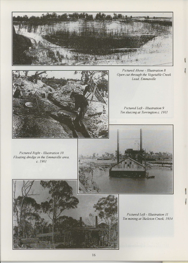
I have prepared a slide show using the numerous plates from this book (viewable on my YouTube site here).
I wish to acknowledge the source of these photographs now and thank the 
Geological Survey of NSW for making this resource available.
You will soon see if you look through the DIGS listings that there is a huge volume of literature on the subject of tin mining in NSW. Much was written before 1911 and a great deal more since. The New England region was at the heart of the industry. Locations such as Emmaville, Torrington, Tingha and Wilson’s Downfall stand out. Today, however, little mining is going on and it will take a substantial increase in the price of tin to get things moving again. The emphasis then will be on large scale mining and it looks as if the day of the solitary miner or small syndicate is over.

Here are the reference numbers for some other important documents relevant to the subject of tin mining.
The Mineral Resources of NSW (1901) by EF Pittman. DIGS reference number R00051137
The Mineral Industry of NSW by EC Andrews et al 1928. R00050818
Tin (Bulletin No 1) by EJ Kenny 1922. R00050981
Minerama book 1994 Cassiterite downloadable from

Sunday, 6 March 2016

SMITH’S MICA LODE TORRINGTON

In 1993 Minerama adopted beryl as its theme mineral for that year’s show. This led to the compilation of the “Beryl” booklet (downloadable here (No longer available there. You can find it now in this blog) mineral displays and several field trips to beryl localities. One place the organisers visited was Smith’s Mica Lode at Torrington, shown to us by John Griffey. This was the only time I visited the place, but I kept some of the specimens until we moved from Glen Innes in 2013. They contained more beryl crystals (all opaque, sadly) than I have seen from any other locality near Torrington.
Derived from MINDAT. The pink crystal locates Smith's Mica Lode. The granite country and the Torrington sedimentary pendant can easily be distinguished.

It wasn’t easy to get to then and presumably it isn’t today. Access was through private land from the site of Tungsten village and then on foot through the Torrington State Forest. The outcrop is of pegmatite in which beryl, biotite and feldspar dominate. As you can see from the various maps included in this blog, the site is within the Torrington State Forest. It is a couple of hundred metres from the granite boundary and the country rock is sedimentary strata into which the pegmatite dyke has intruded from the granite beneath.
From a 1981 publication on mining at Torrington. Smith's Mica Lode is located top centre. The blue line locates the edge of the granite.

The "Beryl” booklet incorporates quotations from several sources (all of which are no doubt downloadable from DIGS. The link to DIGS is here. (Doesn't work)) I won’t repeat any of this information here. The one reference I have included dates from 1972 but I can’t track down the source. I found it during a search of DIGS. 
The Grafton Maclean Metallogenic Map locates Smith’s Mica Lode by the number 0551. (Green circle, top centre.) The accompanying notes tell us that Be, Bi, W, U, Sn, Zn and Cu minerals have been found there. Mindat (to be found here) gives the following information:

“Smiths mica (Mica lode; Smiths mica mine; Junction reefs), Torrington, Clive Co., New South Wales, Australia. Mineral List: Beryl, 'Biotite', Cassiterite, 'Monazite', Muscovite

Located approximately 7.5km North of Torrington. Coordinates: 370705mE, 6763668mN.
Operated as a shaft and shallow pits 1907 to 1921 and later 1954 to 1957. Grafton-MacLean 1:250 000 map sheet.

The other numbered localities nearby are:

0011 Wren’s NW Workings. Topaz, W, Bi.

0060 The Black Swamp Creek Alluvials. Mindat states: “Black Swamp Creek Alluvials, Torrington, Clive Co., New South Wales, Australia. Located approximately 6 km North of Torrington. Dredging operations from 1907 and sporadically through to late 1950s. Mineral List: Cassiterite, Corundum, 'Monazite', Quartz, Topaz.

This location appears to contain just what fossickers are looking for. Burnt Hut Creek is also part of this system. I would expect to find beryl in the gravel; take note that beryl does not concentrate in a sieve because of its relatively low specific gravity.

0546 Poor Prospect. Mindat states: “Poor Prospect, Torrington, Clive Co., New South Wales, Australia. Located approximately 7 km North of Torrington. Operated as shallow pits. Mineral List: Quartz, 'Wolframite'.

0547 The Wet Deposit. Mindat states: “Wet deposit, Torrington, Clive Co., New South Wales, Australia. Located approximately 7 km North of Torrington. Operated as shaft and shallow pits. Mineral List: Quartz, 'Wolframite'.”

0548 Junction Prospect. Mindat states: “Junction prospect, Torrington, Clive Co., New South Wales, Australia. Located approximately 7 km North of Torrington. Operated as shallow pits. Mineral List: 'Biotite', Muscovite var: Sericite, Quartz, 'Wolframite'.”

0549 Fletcher’s Deposit. Mindat states: “Fletchers deposit, Torrington, Clive Co., New South Wales, Australia. Located approximately 7.5 km North-West of Torrington.
Operated as underground workings, shafts and shallow pits 1913 to 1921. Mineral List: 'Limonite', 'Limonite', Muscovite var: Sericite, Quartz, 'Wolframite', Muscovite var: Sericite'.

0550 Roberts Lode. Mindat states: “Roberts Lode. Located approximately 7.5 km North of Torrington. Operated as a shaft and numerous shallow pits 1910. Mineral List 'Wolframite'.”
0584 Lonely Deposit. Mindat states: “Lonely Deposit, Torrington, Clive Co., New South Wales, Australia. Located approximately 7 km North-West of Torrington. Operated as shallow pits. Mineral List: Quartz, 'Wolframite'.”
1326 Upper Black Swamp Lodes. Topaz, quartz.

From the Beryl book (1993). Specimen from Smith's Mica Lode.

Friday, 20 November 2015

SPECIMEN HILL, THE GULF NEAR EMMAVILLE NSW AUSTRALIA

SPECIMEN HILL, THE GULF, NEAR EMMAVILLE 
NSW AUSTRALIA
 
The mine location is marked at top centre (Mindat)
I’m sorry to say that I have never visited this old mining area, which is along the Carpet Snake Creek fire trail, off the Gulf road, north-west of the New England mining town of Emmaville. It is one of many hundreds of mineral deposits in the area, mostly discovered in the period 1875-1900.
Mindat (here) provides the following location information:
Latitude & Longitude (WGS84):
29° 16' 35'' South , 151° 31' 4'' East
Latitude & Longitude (Decimal Degrees):
-29.2763888889 , 151.517777778
Latitude & Longitude (Degrees plus Decimal Minutes):
-29° 16.5833333333', 151° 31.0666666667'
The workings are on the right hand side of the fire trail about 1km from the Gulf road turnoff, which is on the right not far after the ford across Paradise Creek. Be aware that the access road is not likely to be OK for 2 WD vehicles.

Here are some useful references: Geo-Log 2011 page 64 (here). Geo-Log is an e-zine put out by the Hunter Valley Amateur Geological Society and the whole of it is packed with useful information.

The Mindat article also provides a list of reported minerals from this location: Beryl, var Emerald, 'Biotite', Cassiterite, 'Chlorite Group', Epidote, 'Feldspar Group', Fluorite, 'Monazite', Muscovite’ var: Sericite, Pyrite, Quartz, 'Tourmaline', 'Wolframite'. The quote marks imply that that a mineral group rather than a precisely named mineral species is intended. (The blue colour has to do with links in Mindat which I haven't been able to change.)
Quartz crystal tips (Jewellery Pirate)
Also noteworthy is the inclusion in the article of a photograph of an emerald crystal, which is so typical of those found at the Torrington emerald mine (Cow Flat) that I am certain the specimen came from there rather than from Specimen Hill. To my knowledge, no-one has recorded finding emerald or even beryl at this place. I will gladly change this blog if someone can tell me otherwise.

Note that the Grafton metallogenic map (an extract is shown below) locates Sim’s Deposit (EA0336), Farmer’s Deposit 
Enlarged from the Graton Metallogenic map
(EA0338), the Breakfast Creek Deposit (EA0022) and the Breakfast Creek Alluvials (EA0783) in this area. Several of these (like Specimen Hill itself (EA0335)) are lodes, the others are alluvial. This means that if you are visiting the area, seek out these lesser known spots and in particular do some gem sieving in the gullies – topaz and monazite as well as cassiterite and quartz crystals could be waiting for you. Pretty Gully is to the west of Specimen Hill, Breakfast Creek is on the eastern side. Both contain alluvial cassiterite.

The geology of the locality is well described in “The Mineral Deposits of New South Wales” by Markham & Basden (1974), downloadable from DIGS here (doesn't work 2024), reference number R00037944. The quote following is from page 371.
Two or three kilometres to the west, (ie of the Paradise lodes ed.) on the summit of a high hill, is the Specimen Hill (also known as Mt Garth or Mills) lode (GR 45493722 Grafton 1:250,000). Workings, consisting of cuts, shafts to 20m, and adits, extend for 300m. Thin, tin-bearing veins run in several directions. Some of the vein material is very siliceous, consisting of granitoid quartz (clear, white and brown grains) with scattered vughy inclusions containing tourmaline and minor cassiterite and epidote. Patches rich in chlorite are also present. Drill holes at Specimen Hill (Rasmus 1972 a,b) intersected up to fifteen thin veins, but the cores contained no visible tin. Production is not known.”
 
The earliest reference I can find to mining at this place is in 1910; despite much prospecting work nothing substantial seems to have been discovered then or since. The reference to Rasmus’s report on drilling in 1972 is part of ongoing prospecting from 1971 to at least 1977. From the mineral collecting point of view, I found the comments in a report dated 16.11.77 the most interesting (image opposite). This is the last mention of the site I can find in DIGS.
Candle crystals - Paul Hayes photo
What are you likely to find at Specimen Hill? Quartz crystals for sure, including the fascinating “candle crystals” (which look like they have had wax poured over them); crystal groups; possibly cassiterite crystals and probably schorl tourmaline, epidote and chlorite – if you are lucky, several of these in the one specimen.
Quartz crystal group - Paul Hayes photo
I have no photos of my own of Specimen Hill; I would like to acknowledge those I have copied from  Paul Hayes’ “Wild Frontier Crystals” site (here).(Can't be found)