Search This Blog

Showing posts with label Mole Tableland. Show all posts

Sunday, 6 March 2016

SMITH’S MICA LODE TORRINGTON

In 1993 Minerama adopted beryl as its theme mineral for that year’s show. This led to the compilation of the “Beryl” booklet (downloadable here (No longer available there. You can find it now in this blog) mineral displays and several field trips to beryl localities. One place the organisers visited was Smith’s Mica Lode at Torrington, shown to us by John Griffey. This was the only time I visited the place, but I kept some of the specimens until we moved from Glen Innes in 2013. They contained more beryl crystals (all opaque, sadly) than I have seen from any other locality near Torrington.
Derived from MINDAT. The pink crystal locates Smith's Mica Lode. The granite country and the Torrington sedimentary pendant can easily be distinguished.

It wasn’t easy to get to then and presumably it isn’t today. Access was through private land from the site of Tungsten village and then on foot through the Torrington State Forest. The outcrop is of pegmatite in which beryl, biotite and feldspar dominate. As you can see from the various maps included in this blog, the site is within the Torrington State Forest. It is a couple of hundred metres from the granite boundary and the country rock is sedimentary strata into which the pegmatite dyke has intruded from the granite beneath.
From a 1981 publication on mining at Torrington. Smith's Mica Lode is located top centre. The blue line locates the edge of the granite.

The "Beryl” booklet incorporates quotations from several sources (all of which are no doubt downloadable from DIGS. The link to DIGS is here. (Doesn't work)) I won’t repeat any of this information here. The one reference I have included dates from 1972 but I can’t track down the source. I found it during a search of DIGS. 
The Grafton Maclean Metallogenic Map locates Smith’s Mica Lode by the number 0551. (Green circle, top centre.) The accompanying notes tell us that Be, Bi, W, U, Sn, Zn and Cu minerals have been found there. Mindat (to be found here) gives the following information:

“Smiths mica (Mica lode; Smiths mica mine; Junction reefs), Torrington, Clive Co., New South Wales, Australia. Mineral List: Beryl, 'Biotite', Cassiterite, 'Monazite', Muscovite

Located approximately 7.5km North of Torrington. Coordinates: 370705mE, 6763668mN.
Operated as a shaft and shallow pits 1907 to 1921 and later 1954 to 1957. Grafton-MacLean 1:250 000 map sheet.

The other numbered localities nearby are:

0011 Wren’s NW Workings. Topaz, W, Bi.

0060 The Black Swamp Creek Alluvials. Mindat states: “Black Swamp Creek Alluvials, Torrington, Clive Co., New South Wales, Australia. Located approximately 6 km North of Torrington. Dredging operations from 1907 and sporadically through to late 1950s. Mineral List: Cassiterite, Corundum, 'Monazite', Quartz, Topaz.

This location appears to contain just what fossickers are looking for. Burnt Hut Creek is also part of this system. I would expect to find beryl in the gravel; take note that beryl does not concentrate in a sieve because of its relatively low specific gravity.

0546 Poor Prospect. Mindat states: “Poor Prospect, Torrington, Clive Co., New South Wales, Australia. Located approximately 7 km North of Torrington. Operated as shallow pits. Mineral List: Quartz, 'Wolframite'.

0547 The Wet Deposit. Mindat states: “Wet deposit, Torrington, Clive Co., New South Wales, Australia. Located approximately 7 km North of Torrington. Operated as shaft and shallow pits. Mineral List: Quartz, 'Wolframite'.”

0548 Junction Prospect. Mindat states: “Junction prospect, Torrington, Clive Co., New South Wales, Australia. Located approximately 7 km North of Torrington. Operated as shallow pits. Mineral List: 'Biotite', Muscovite var: Sericite, Quartz, 'Wolframite'.”

0549 Fletcher’s Deposit. Mindat states: “Fletchers deposit, Torrington, Clive Co., New South Wales, Australia. Located approximately 7.5 km North-West of Torrington.
Operated as underground workings, shafts and shallow pits 1913 to 1921. Mineral List: 'Limonite', 'Limonite', Muscovite var: Sericite, Quartz, 'Wolframite', Muscovite var: Sericite'.

0550 Roberts Lode. Mindat states: “Roberts Lode. Located approximately 7.5 km North of Torrington. Operated as a shaft and numerous shallow pits 1910. Mineral List 'Wolframite'.”
0584 Lonely Deposit. Mindat states: “Lonely Deposit, Torrington, Clive Co., New South Wales, Australia. Located approximately 7 km North-West of Torrington. Operated as shallow pits. Mineral List: Quartz, 'Wolframite'.”
1326 Upper Black Swamp Lodes. Topaz, quartz.

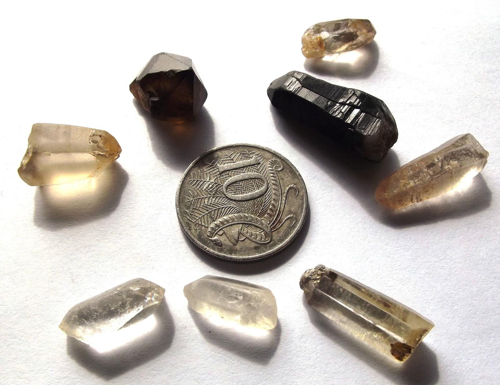
From the Beryl book (1993). Specimen from Smith's Mica Lode.

Tuesday, 25 November 2014

REID’S COPPER MINE, NEAR EMMAVILLE NSW AUSTRALIA

REID’S COPPER MINE, NEAR EMMAVILLE 
NSW AUSTRALIA

My attention was first drawn to a place of this name when I was looking over the Grafton 1:250000 geological map. I can’t locate a download site for this map, but you can get the 2001 Metallogenic map here. (The material to be found at this website is new to me and looks to be very useful). I was primarily interested in locating Webb’s Silver Mine (see my Blog on that place). Right on the road from Emmaville is the number 12, which the legend tells me is the location of Reid’s Copper Mine. On the 2001 map the number is 1053.
I made the trip out there on the 10th October, 1988. The spot is on the left hand side of the road, shortly after a steep climb. This is the Grampians ridge and there are good views back towards Emmaville and ahead to the Mole Tableland. The location (at
that time, anyway) is entirely in the road reserve. I observed two shafts, nearly filled in with rock rubble and general rubbish. A narrow mineral vein was present in the wall of one of the shafts and the rock appeared to be quartzite. There was some quartz feldspar porphyry on the dumps. I collected specimens of malachite, azurite, a sulfide mineral (which was most likely chalcopyrite or pyrite) and fluorite from the dump. There was clear, pale green and occasionally purple fluorite scattered all over the dump, especially on the side away from the road.

Subsequently, I described the location as a possible self-guided field trip in the first Minerama book (Molybdenite) which may be downloaded from this Blog (February 2024). This made the place well known to fossickers, so whether or not you can still collect similar material today I can’t say. If someone has been there recently, then making a comment (below) letting us all know what the place is like now, would be most welcome.

Here is the earliest report I have been able to find. It’s from Edgeworth David’s report of 1887 “Geology of the Vegetable Creek Tin-Mining Field”, page 160. You can download the entire document from DIGS: Reference number R00031676. Note that there is no mention of fluorite.
This extract is from the report titled “Grafton Maclean 1:250 000 Metallogenic Map - Metallogenic Study and Mineral Deposit Data Sheets (metallogenic explanatory notes)” downloadable from DIGS. The reference number is R00056102. The map referred to in paragraph 1 is included in the download.
When you read this, it is obviously referring to the same place I visited in October 1988. Again, it is curious that there is no mention of fluorite. There are several possible explanations. One is that I mistakenly identified some other mineral as fluorite, perhaps quartz. This is unlikely, because I’ve been there with others several times since and we have always found fluorite on the dump. Another is that when the geological field work was done for the metallogenic study, the location was confirmed but the information on the minerals was taken from David’s 1887 report. If this in fact some other prospect and not actually Reid's Copper Mine, then we have a possible solution to the dilemma.

JE Carne’s report “The Copper Mining Industry and the Distribution of Copper Ores in New South Wales” (1908) (DIGS reference R00050669 ) gives information about numerous copper mines and prospects. The New England section begins on page 304. Scanning through this “mine of information” shows that, in the Emmaville district, copper minerals and fluorite had been found together at the Bald Nob Mine, about 5 miles north of Emmaville, and Portion 2, parish Paradise North, County Gough. So there is certainly a precedent locally for this type of occurrence. Perhaps there has been some confusion between locations at some point.

Another useful reference on the Net is Mindat (here). This is a remarkable world-wide data base on almost anything to do with minerals. Searching for “Reid’s Copper Mine” only gives information we’ve already quoted above; there is no mention of fluorite. David places it in "Portion 600, Parish of Strathbogie North". Mindat says "Portion 61". 

Bald Nob Mine” confirms the occurrence of fluorite and copper minerals. The location of the mine is said to be approximately 2km north-east of Emmaville. Searching for “fluorite” and “Emmaville” simultaneously brings up quite a few fluorite localities, amongst which is “Reids/Willowie Mine”, approximately 3km north-east of Emmaville. Then there is “Say’s Prospect”, approximately 6km WNW of Emmaville, Wells’s Lode 1, approximately 6km north-west and Well’s Lode 3, approximately 7.5 km north-west.
All this suggests that there must be more mine dumps in the area worth locating. Add a comment below if you would like to share further information.


Sunday, 11 August 2013

BERYL FROM TORRINGTON, NSW AUSTRALIA

BERYL FROM TORRINGTON, NSW AUSTRALIA

Various Torrington localities
Gem and mineral collectors who visit Torrington are mostly interested in the three minerals quartz, beryl and topaz. Of these, beryl is perhaps the most desirable, especially in its varieties aquamarine and emerald, both of which occur at Torrington.

I have already written several Blog entries dealing with Torrington which I recommend you should read. Take note of the reference material listed and if you haven’t downloaded these yet be sure to do so. The entries are: DOWNLOADING PDF DOCUMENTS FROM DIGS, TORRINGTON – ESSENTIAL READING, HEFFERNAN’S WOLFRAM MINE TORRINGTON, MINERAMA BOOK DOWNLOADS FROM ALF, and SCRUBBY GULLY, TORRINGTON NSW. Use the search box at the top of the page to locate them.

Other useful references include: The Mineral Industry of New South Wales (6) Beryllium (EO Rayner 1958) and the Grafton-Maclean Metallogenic Data Sheets which can be located in DIGS by a search. Anyone seriously interested in the minerals of northern New England should study this document and the companion volume on Inverell.

The two quotes below from this latter reference provide an excellent background and give locations which can be tracked down using The Mole Tableland 1:50 000 “Geology and Mineral Occurrences” map, also downloadable from DIGS.

Beryl gems.                                

Beryl, aquamarine and rarely emerald are present in small quantities in watercourses draining the Torrington Pendant. Notable localities include Highland Home body (502), Diggers Creek and Flagstone Creek and Scrubby Gully mine.”
The Emerald Mine, Cow Flat

Beryl and emeralds.

There are 35 occurrences containing beryl and/or emerald. Most of these occurrences are located on or near the sedimentary rock/granite contact in association with silexite. This is especially the case in and around the Torrington Pendant (Emerald mine, 459; Heffernans mine, 1332; and Griffeys emerald occurrence, 463). The beryl occurs in lodes controlled by vertical joints and shears. The beryl generally occurs as one of several gangue minerals in association with quartz and/or topaz along with, mainly, wolframite and bismuth and, to a lesser extent, cassiterite and other polymetallic minerals.

The beryl is generally found as coarse euhedral individual light green, yellow–green to blue–green to green (emerald) crystals within quartz–biotite–topaz and/or feldspar pegmatites. Rare aquamarine has also been found. Beryl also occurs in banded coarse crystalline veins up to several centimetres wide (Smith's mica [lode], 462) and in massive crystalline pods up to 25 cm in size (Chance Find [prospect], 1130). Light green to clear beryls with multiple emerald bands have also been found at the Emerald mine (459).
Scrubby Gully Alluvials

There are three known groups of emerald occurrences, all with a northeast trend. These are de Milhous (1191) and associated mines, the Emerald mine (459), and Griffeys emerald occurrence (463). De Milhous mine is the largest recorded producer and the only known commercial emerald deposit in New South Wales. There the emeralds were found largely in bunches and in many places firmly embedded in a quartz–topaz matrix (Mumme 1982). The lode is polymetallic, consisting of a quartz–feldspar pegmatite that has undergone argillic and kaolinitic alteration. The emeralds are associated with minor cassiterite and base metals, with banded quartz, topaz, fluorite (purple and green), arsenopyrite, kaolinised feldspar, coarse biotite and muscovite. The total recorded production is 26 000 carats of unknown quality produced mainly from 1891 to 1909. Several other lodes have been worked within two kilometres (southwest and northwest) of the mine. These are Goggitts shaft (1183); The Colossal mine (1186), The Glen (1187) and Bald Nob mine (1194).” (NOTE: the de Milhous' mine is the same as the one known as The Emmaville Emerald Mine. I have written a blog on this locality.)
Specimen 15mm X 4mm. Emerald Mine, Cow Flat (Torrington)

Friday, 21 June 2013

HEFFERNAN’S WOLFRAM MINE TORRINGTON NSW AUSTRALIA

HEFFERNAN’S WOLFRAM MINE TORRINGTON NSW AUSTRALIA

0.5 carat facetted beryl
Heffernan’s Mine (Heffernan Brother’s Mine) is one of the classic mineral collecting localities at Torrington. 
It is on private property (Highland Home) north of the Butler Mine/Mystery Face road, as marked on the map, which locates both the mine’s location and the Butler Mine turnoff from the Silent Grove road. 

The map itself is taken from the Torrington (Mole Tableland) map referred to in a previous Blog. As you will see, there are numerous other mines and prospects nearby, both on the private land and in the Conservation Area. Heffernan’s Mine is identified as 0272.
Rasmus (1969) reports on this location as follows:
“ML 52, Parish Highland Home, County Gough. This deposit was proved by shallow shafts and trenches for a distance of about 400 feet. The deepest shaft was about 40 feet. The lode strikes 030° in granite. The lode at the southern end of the deposit consists of decomposed micaceous rock, with vugs containing quartz, feldspar and mica crystal aggregates and occasional prisms of beryl. The wolframite occurs in bunches and is not continuous. At the northern end of the deposit the lode consists of aplite with small amounts of wolframite distributed throughout.”


I have collected there several times and always came back with small, but well-formed quartz crystals, and some pale green beryl.
Specimens are 2-3 cm across
Many people have been here over the years, so if you succeed in getting permission to go into the site, you will have to work for your finds.

Please let us know in the comments section of any previous finds you may have made here and if you succeeded in gaining access to the site.

There is more information in the 1993 Minerama book “Beryl” (see in this Blog March 2024) and in the Gemstones books downloadable from DIGS.  Also worth downloading is the Mineral Industry booklet “Tungsten No. 41, complied by PL Rasmus, April 1969”. The DIGS reference is Industry 41.


Wednesday, 12 June 2013

TORRINGTON NSW AUSTRALIA – ESSENTIAL READING

TORRINGTON NSW AUSTRALIA – ESSENTIAL READING

The Torrington area of NSW is one of the more prolific mineral collecting areas in Australia. Most of the area consists of coarse granite (the Mole Granite) near the centre of which is the Torrington Pendant, part of the original roof of the intrusion, consisting of a series of sedimentary rocks.

There is extensive mineralisation throughout the area, especially near the granite margins and particularly in and around the sedimentary pendant.
Collectors have made the most of the variety and quality of the minerals to be found right from the earliest days of mining in the 1870’s. Today, at any time of the year, you will find people searching the old mine dumps and creek beds for specimens, especially quartz crystals, topaz and beryl.
 DIGS has a vast collection of information on Torrington. (See my blog entry  DOWNLOADING PDF DOCUMENTS FROM DIGS). Simply go to the site and type “Torrington” into the “Locality” box. You can explore 130 years of accumulated knowledge written by the people who were there.

For those needing something in a hurry, here are some documents you can download which I have called “essential reading”.
 
 The Tin Mining Industry and the Distribution of Tin Ores in New South Wales” by JE Carne, 1911. The DIGS  reference is “Mineral Resources 14”. It’s not just about Torrington, of course, but gives lots of good information about the area.


A similar book is “The Tungsten Mining Industry in New South Wales”, also by JE Carne, published in 1912. The DIGS reference is “Mineral Resources 15”.


This edition of “Quarterly Notes”, number 17 from October 1974, has an interesting article on the silexite deposits found in and around the Torrington Pendant. Silexite is the quartz-topaz rock found in large masses near the intrusive contacts. The DIGS reference is “QNO 17”.


The Mole Tableland 1:50 000 “Geology and Mineral Occurrences” map is a comprehensive listing of mines and mineral locations which should keep you busy for some time, especially if you go back to DIGS looking for more information on a particular place. The reference is “Map R00041396”.

Why not check out my You Tube channel here .