Search This Blog

Showing posts with label granite. Show all posts

Monday, 11 March 2024

KINGSGATE MINES Part 4

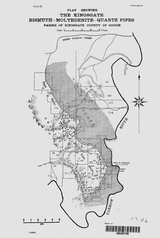
DESCRIPTION AND LOCATION OF THE MAIN PIPES
For much of this information, we are indebted to the geologists of the NSW Geological Survey, in particular to Mr. E.C. Andrews, whose work "The Molybdenum Industry in New South Wales" was published in 1916. To avoid any confusion with names and the numbering system, it needs to be understood that the numbers appearing on the map in Andrews' report are those assigned by Mr. W.H. Yates to pipes under his control in 1915. Numbers appearing as part of names refer to the Portions of Parish Kingsgate and therefore relate to the original mining leases of the 19th Century. Pipes under Sachs' control at that time or under the control of other miners and prospectors were either not numbered at all or assigned letters. The descriptions which follow treat the pipes essentially in order from the north, Portion by Portion.


Portion 24.
1. Known as “Quinn's Find” - a prospect only.

Portion 6. (originally leased by Feeney, Rush and Say in 1879)
2. Dips at 1:2; a branching pipe, an unimportant producer.

3. Prospect only.

4. Small vertical pipe.

Portion 1.
47. The “Swamp Blow”. A prospect north of the present main road in a swampy area.

5. Usually known as the "One and Nine" from its location on the portion boundaries. This pipe has been an important producer of both bismuth and molybdenite and is apparently the site of Quinn's discovery of "sulfur" in 1877. The upper part of the pipe has been mined as an open cut which now lies quite close to the main road. In cross section, the pipe varied in diameter from 1 to 8 metres. It has been mined to a depth of about 85 metres, and consisted essentially of a gangue of well crystallised quartz with rich deposits of bismuth and molybdenite. Vughs lined with crystals of white and black quartz crystals up to 1.2 metres in length were found. Several branches of the main pipe were noted at depth.


6. Prospect only.

Portion 9.
7. The “Water Shaft”, “Tin Shaft” or “Tin Show”. This was the second pipe to be prospected in 1872. Small quantities of cassiterite were found in the quartz. The pipe, which is nearly vertical, has been prospected to a depth of 12 metres.

45. Known as "Jack's at Home". Prospect only.

46. Prospect only.

Portion 100. (Originally in four blocks, leased by Quinn & Ferguson in 1879)
9. “Bill Miller's Hole”. A fairly large but poor pipe prospected to a depth of 10 metres.

40. “Jubilee Pipe”. A surface prospect only.

48. Prospect only.

10. The “Wolfram Pipe”, “Wolfram Blow”, “Old 26” or “Little Tunnel”. This particular pipe was the one originally prospected in 1872. While it contains a little cassiterite in a massive white quartz gangue, the pipe is notable for the quantities of wolframite and arsenopyrite it contains along with the usual bismuth and molybdenite. Both can be readily found on the dumps. Initially mined as an open cut, it was later worked by a tunnel to a depth of 30 metres. The maximum diameter reported was 3.7 metres. Commercial quantities of wolframite were mined here in 1950-52.

31. Prospect only.

37. “Tom Key's Hole” or the “Chimney Shaft”. A fairly small, steeply dipping pipe worked to a depth of over 45 metres.

8. The “Black Shaft” or “26 East”. This large pipe produced substantial quantities of ore in the early days, when it was followed down to a vertical depth of over 40 metres.

11. “Mick's Shaft”. A vertical pipe of moderate dimensions.

12. Prospected at the surface only.

35. The “Granite Shaft”. Instead of the usual quartz, the molybdenite and bismuth were found here in a gangue of granite, in which the felspar was largely sericitised. The pipe, a moderately deep one, dips steeply and branches into two at depth. It has been mined to a depth of at least 40 metres. For the first 30 metres, the ore occurred in the granite itself. One branch continued as granite, the other was a typical quartz pipe.

36. Known as the “25 Northwest No.2 Pipe”. It is small and has been prospected to only a shallow depth.

34. The “Mount Morgan Pipe” is a large pipe (up to 7.6 metres across) located at the highest point on the plateau, on top of a rocky knoll on the left of the access track. It dips quite steeply to a depth of more than 50 metres below the surface. The workings are still fairly accessible but should not be entered.

32. The “25 West”. A surface prospect only.

13. The “25 North”. This pipe has been one of the largest producers of both bismuth and molybdenite at Kingsgate. It has been followed down to over 150 metres from the surface, at first at a fairly shallow angle, then more steeply when it became necessary to sink a vertical shaft to facilitate mining. The pipe branches at several places. The quartz gangue was in places marked by large vughs which were lined by huge quartz crystals. The dumps of this mine yielded quantities of radio quality quartz during World War 11.

14. The “Old 25”. This was another pipe first mined as an open cut and later mined underground. Mined to a depth of 76 metres, the Old 25 was one of the largest pipes on the field. A haulage tunnel was driven into the base of the workings to facilitate access. Most of the workings are still accessible but should not be entered. The mine lies to the right of the access track and its dump also yielded crystals during the war. More recently the dumps have yielded many fine mineral specimens.


38. “25 South No.2”. A fairly shallow prospecting shaft.

33. “25 South”. Similar to its neighbour.

15. “Weidmeyer's Cutting”. A vertical pipe of moderate dimensions mined to a depth of 30 metres.

16. “Martin's Hole”. A small vertical pipe.

Portion 27.
17. Prospect only.

Portion 28.
18. “Schoolhouse Blow”. Prospect only.

19. “Magazine” or “Windlass Shaft”. Prospect only.

21. “28 South”. Prospected on the surface only.

Portion 42.
20. Prospect only.

Portion 49.
22. Prospect only.
Portion 40. (Yates' original lease of 1880)
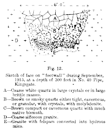
23. “Forty North”. This was another of the very productive pipes. It was originally abandoned because of its poor showing on the surface, but rich bismuth ore was later discovered in it by the discharge of water from a race eroding the weathered granite. The pipe descends in stages to at least 30 metres below the surface. The quartz gangue was at times either massive or cavernous, containing grey and black crystals. Both bismuth and molybdenite were mined in large amounts.

24. “Forty” adjoins Forty North to the south. The surface rubble of white quartz yielded much bismuth which was followed downwards in an open cut for about 6 metres. In later years the pipe was followed vertically for about 90 metres, continuing to produce quantities of bismuth and lesser quantities of molybdenite. The quartz occurred in massive form and as large white and smoky crystals.

39. Prospect only.

41. “Road Block Pipe”. A small unimportant hole about 10 metres deep.

42. Prospect only.

25. “Forty South”. Another small producer about 20 metres deep.

51. “The Reef Blow” is a pipe with three main branches, initially mined in a gently inclined tunnel which later became vertical. Both bismuth and molybdenite were produced.


Portion 41.
44. A small pipe mined for quartz in 1942.

26. “Jim Marshall's Hole”. A surface prospect only.

27. Prospect only.

28. Known as the “Arsenic Blow”, “Arsenic Shaft” or “Hagen's Tribute”. This is another of the pipes known from the early days of the field. Like many of the pipes, it was first mined as an open cut but subsequently underground as the dip of the pipe changed from vertical to nearly horizontal and vertical again as the pipe was followed down. The pipe was approximately 3 metres in diameter and was traced downwards for about 60 metres. The gangue was, as usual, quartz - sometimes massive and frequently cavernous. Some of the vughs encountered were more than 3 metres long, lined with large quartz crystals. In 1942 the old shaft was dewatered and the mine worked again specifically for quartz crystal. The Arsenic Shaft appears to have been the main producer of crystal at Kingsgate.

43. “Christie's Blow”. A prospect only.

ML 45 and Adjoining Leases.
“Monkey Shaft”. Described as more of a vein than a pipe, it was worked to a depth of about 13 metres. At depth the vein gave way to a true quartz pipe. This deposit was among several in this corner of the field tested for crystal in 1942.

“The Wet Shaft”, “Water Cut” or “Wet Cut”. This pipe was mined to a depth of about 60 metres, producing good yields of both bismuth and molybdenite. The quartz gangue was noticeably cavernous and the dumps were turned over for crystal during the war.

The “Old 45” or “Sachs' Pipe”. This pipe is the most famous of all those at Kingsgate because of the exceptional masses of molybdenite extracted from it. It probably produced more mineral than any other pipe on the field. It was first worked for bismuth but was then abandoned because of the high molybdenite content of the ore which made it difficult for the miners to produce a pure bismuth concentrate. In 1902 the mine was reopened by Mr. Valentine Sachs, who soon discovered a large vugh more than 15 metres across. This extraordinary cavity was lined with massive quartz and molybdenite crystals. One piece of solid molybdenite removed was said to have weighed about 1 tonne. After producing many tonnes of ore, Sachs evidently lost the course of the pipe and therefore sold the mine. The new owners subsequently discovered that the pipe had constricted to only 50 cm in diameter. They followed the pipe downwards, but no further bonanzas of ore were located. The total length of the workings approaches 100 metres, most of which is still accessible.
“Goodwin's Pipe” was mined to a depth of about 60 metres at an angle of about 45o. Good yields of bismuth and molybdenite were obtained. Because access was from a cutting just above creek level, the workings are now completely flooded. Calcite cementing pieces of quartz pipe material was a feature of this pipe.
Portion 44.
29. “The Hard Blow”. A small pipe mined to only a shallow depth.

49. Prospect only.

30. “Sachs' Folly”. Prospected on the surface only.

50. “Nield's Blow”. Prospect only.

ML 90 (formerly “Sachs' Prospecting Area”.

F. This pipe, also known as “Potter's Claim”, yielded fairly large amounts of ore.

G. Known as the “Reef Blow”. (Not to be confused with Pipe 51 also of that name.) This is another of those pipes which appeared more like a vein in places. It produced good yields of molybdenite.

H. “The Giant Blow” is well known for the very large doubly terminated quartz crystals found in the gangue. These were first located right at the surface. The pipe produced quantities of bismuth and molybdenite from an open cut which was then followed down into underground workings. These are still accessible.

I. No details available.

J. No details available.

ML 55 (formerly “Pauline Speckhardt's Lease”
A. A small pipe containing both bismuth and molybdenite in minor quantities.

B. This fairly small pipe produced many tonnes of rich ore containing both metals.

C. This pipe, followed down for more than 30 metres, produced bismuth in fair amounts.

D. No details available.

E. No details available.

Mines South of Yarrow River.
From Kingsgate, the boundary between the Permian metasediments and the granite has been traced southwards for many kilometres. Ore bearing pipes have been found in two areas across the Yarrow River not far from the Kingsgate pipes and obviously related to them.

Portion 19, Parish Yarrow.
The “Dodger Claim” (“Maurer's Claim”) includes 4 pipes near the granite boundary.
1. Yielded good quantities of both bismuth and molybdenite. The pipe is relatively large by Kingsgate standards.

2. A smaller pipe with smaller quantities of molybdenite.

3. Another pipe of moderate size followed down for at least 20 metres. Good quantities of both bismuth and molybdenite were mined along with large amounts of well crystallised quartz, generally smoky.

4. Similar to the previous pipe.

Portions 20-23.

More pipes have been prospected in this area, a little north of the Pretty Valley Road.

Saturday, 9 March 2024

KINGSGATE MINES Part 3

THE GEOLOGY OF KINGSGATE

The casual visitor may overlook the intimate relationship between the ore bearing pipes and the granite/metamorphics contact, but the miners were well aware that the ore bodies were always found within the granite and never more than a few hundred metres from its margin. That this is more than a co-incidence was borne out during mining when it was often found that the pipes dipped into the earth more or less parallel to the contact.

It will be necessary to examine briefly the geological structure of the district to understand the origin of the mineral deposits. The rocks throughout New England reveal a complex history of marine and nonmarine sedimentation, explosive volcanic activity and widespread intrusion of granitic magma. This is consistent with what is found today along growing continental margins, where marine sediments are subducted beneath thicker continental crust by plate movements. Such a situation occurs today in Japan, which probably resembles the New England of the late Palaeozoic era. At Kingsgate, metamorphosed sediments of probable Permian age have been intruded by late Permian/early Triassic granite. Mineralisation is confined to 70 or more roughly cylindrical ore bodies within the granite, at a short distance from its intrusive contact.

Molybdenum mineralisation in New England is mostly located in a NE/SW trending zone including the deposits at Wunglebung, Deepwater, Glen Eden, Kingsgate and Booralong. At each place the mineralisation is near an intrusive granite margin, sometimes in pipe formations (as at Kingsgate and Deepwater) and sometimes associated with aplite and pegmatite bodies within the granite (as at Booralong). Similar relationships have been observed in North Queensland deposits. It would appear that volatile components of the magma, containing quartz, sulfur, bismuth and molybdenum in solution, have crystallised within the mostly solidified granite at a late stage of the cooling of the intrusion.

The most prominent of the igneous rocks at Kingsgate is a coarse, mottled grey adamellite, rich in quartz and orthoclase, nonporphyritic and with no apparent structure. It differs noticeably from the tin bearing granites seen, for example, at Torrington. The common dark minerals within the granite are biotite and hornblende. However, this rock does not appear to be the actual host rock for the deposits, which is more likely to a very acid granite usually not seen in outcrop but generally reduced to a thick gravelly soil. Several other granitic bodies also outcrop in the area. The former sedimentary rocks intruded by the granite may be seen in road cuttings below the mines and along the Yarrow River. They are essentially altered siltstone of presumed Permian age. No fossils are known from these rocks at Kingsgate, but Permian marine fossils have been found in similar rocks further south.

There has been considerable speculation as to the reasons why the Kingsgate mineralisation occurs in the way it does. The best that can be said is that the pipes are separate intrusions into the main plutonic mass, whose location has been controlled by the pressure and temperature conditions prevailing at the time. The pipes are very irregular in shape and structure and frequently change direction, dip and diameter as they are followed downwards. Some are characterised by branches, others by their variation in diameter from a few centimetres to many metres across. In some the minerals completely fill the pipe, in others there are open spaces lined with huge quartz crystals. All are of the same essential character, being composed in part of granite in which the felspar has been altered to sericite, in part of quartz and in part of veins and segregations of ore minerals.

Sach's Pipe (the Old 45) has been studied in some detail. More information on individual pipes is to be found in the next chapter.


Song Studies. Bible studies based on hymns and songs
Shoalhaven District Geology.

Friday, 22 July 2016

TOPAZ LOCALITIES WEST OF TORRINGTON NSW AUSTRALIA

TOPAZ LOCALITIES WEST OF TORRINGTON NSW AUSTRALIA

In this blog I’ve attempted to bring together a list of all the places where topaz has been reported to the west of Torrington, in the New England region of NSW. So as not to repeat a lot of what I’ve already written, I’ve given references to some of my articles (in John’s New England Minerals blog). In some cases the reference to topaz may be very minor.
Please note that many of these locations are on private property and you will need permission from the owner to enter.
There are a number of useful references you can download. Firstly, there is the Minerama booklet “Topaz” (here). This gives information and references on many topaz localities in the New England region. (You will need to search Google to find a downloadable copy of this booklet. In searching use topaz book Minerama 1995 as key words. It appears later in this Blog.

Secondly, there is Edgeworth David’s report on the Vegetable Creek Tin Field, published in 1887. It contains an amazing amount of information on what is still a pretty remote part of the country. At the time the report was compiled, only 50 years had passed since the first Europeans entered the district. You will need to go to DIGS (here). The reference number R00030528 will bring up a PDF of a 2 page map which is invaluable in locating old mines and workings. The same map, but on a single page this time, is at the very end of the report itself, for which the reference number is R00031676.

Thirdly, there are the Grafton-Maclean and Inverell metallogenic maps and data sheets, which are comprehensive reports covering all significant (and often insignificant) mines and mineral deposits, with lots of geological and mineralogical details. The respective DIGS reference numbers are R00056102 and R00050906 .

Fourthly, there is the mineral data base Mindat (here), where searching can often bring up information on a particular location. Much of this has been extracted from the previously mentioned reports.
Here are the links to areas already covered in my Blog:
Scrubby Gully topaz
Gaden’s Lode Gulf Road Emmaville (here)
Specimen Hill, The Gulf Near Emmaville (here)
The Gulf Fluorite Mine Near Emmaville (here)
Scrubby Gully, Torrington (here)
Surface Hill Gem Deposit Gulf Road Emmaville (here)
The Emerald Mine, near Emmaville (here).
These are well known localities, which have been visited by collectors and gem hunters for many years. This is not to say that there is nothing of interest left, on the contrary we continue to hear of attractive (and sometimes valuable) specimens being found in these places.
Fossicking at Surface Hill
West of the Beardy River, and entirely on the Inverell 1:250000 sheet, David reported the existence of numerous alluvial tin deposits, many of which are “deep leads”, lying beneath the extensive basalt flows which cover much of the area. I haven’t heard of anyone looking for gems in the area, but David’s descriptions mentions them several times.
The familiar ones are at Scrubby Gully and Surface Hill (both east of the Beardy). Links to my blogs on these are given above. That the topaz, beryl etc at SG and SH have originated from pegmatites around the edges and roof of 
Cross section of a lead (David)
the Mole Granite is beyond doubt. The same is most likely to be true of the deposits listed below. These gem bearing alluvials are probably derived from sources which have long since eroded away.
All these quotations are from David.
The Kangaroo Flat Lead. Details are on pages 93-94. The location is to the west of  Emmaville. “near the north-east corner of Portion 45, Arvid, at the Avoca Mine near the north-east corners of 104 and 105 in the same parish.” “The gravel averages 2 feet in thickness, and is composed principally of flattish, oval pebbles of claystone 2-3 inches in diameter, and well-worn pebbles and grains of quartz; and gem-stones, as green beryl, emerald, sapphire, topaz etc and fine grains of stream tin chiefly black.”
Hall’s Sugarloaf. Details are on page 95. “Half a mile south-west of Foley’s is Hall’s Sugarloaf, a
small outlier of basalt capping stanniferous gravel.” “The deposit may be described as a “cement” consisting of pebbles of claystone 3 inches in diameter with small well worn quartz pebbles, quartz sand, and small gems, as topaz and beryl, set in white and grey pipeclay, which has been baked in places into a tough natural brick.” Quite a few other mines in the area are also described, but no mention is made of gemstones. I think we can safely assume that gems are present in the wash at these places.
The Rocky Creek Lead. “The tertiary country embraced under this name extends from Cockatoo to the water-parting between the Severn and Dumaresq Rivers in the parish of Lorne, a distance of 9 miles.” “At the Basalt Hills the gravel has been tested by several shafts and two tunnels. The alluvial beds are composed chiefly of fine quartz sands such as results from the waste of quartz-porphyry (containing a number of beryls), with pebbles of claystone up to 1 inch in diameter.”
“The Gem Lead has been proved to be a rich feeder, falling into the main body of basalt from the north-east.” “The commencement is in an outlier of quartz sand and gravel, capped by basalt in portion 38, Lorne.” “The richest yield here was 3 tons of stream tin from 70 cubic yards of wash. Emeralds and sapphires are associated with this stream tin.”
The Ruby Hill Lead. “The width of the volcanic formation varies from 5 chains to 2 miles.” “Constituents of the gravel are well rolled pebbles of clear and opaque quartz, red and black jasper, and pebbles of quartz-porphyry, the last attaining the diameter of 1 foot. Zircons and sapphires are plentifully intermixed with the stream tin.”
Beginning on page 164 David gives a summary of gems found in the Vegetable Creek area.
I would be delighted to hear from anyone who makes gemstone discoveries in this area. The comments area below can be used.

Sunday, 6 March 2016

SMITH’S MICA LODE TORRINGTON

In 1993 Minerama adopted beryl as its theme mineral for that year’s show. This led to the compilation of the “Beryl” booklet (downloadable here (No longer available there. You can find it now in this blog) mineral displays and several field trips to beryl localities. One place the organisers visited was Smith’s Mica Lode at Torrington, shown to us by John Griffey. This was the only time I visited the place, but I kept some of the specimens until we moved from Glen Innes in 2013. They contained more beryl crystals (all opaque, sadly) than I have seen from any other locality near Torrington.
Derived from MINDAT. The pink crystal locates Smith's Mica Lode. The granite country and the Torrington sedimentary pendant can easily be distinguished.

It wasn’t easy to get to then and presumably it isn’t today. Access was through private land from the site of Tungsten village and then on foot through the Torrington State Forest. The outcrop is of pegmatite in which beryl, biotite and feldspar dominate. As you can see from the various maps included in this blog, the site is within the Torrington State Forest. It is a couple of hundred metres from the granite boundary and the country rock is sedimentary strata into which the pegmatite dyke has intruded from the granite beneath.
From a 1981 publication on mining at Torrington. Smith's Mica Lode is located top centre. The blue line locates the edge of the granite.

The "Beryl” booklet incorporates quotations from several sources (all of which are no doubt downloadable from DIGS. The link to DIGS is here. (Doesn't work)) I won’t repeat any of this information here. The one reference I have included dates from 1972 but I can’t track down the source. I found it during a search of DIGS. 
The Grafton Maclean Metallogenic Map locates Smith’s Mica Lode by the number 0551. (Green circle, top centre.) The accompanying notes tell us that Be, Bi, W, U, Sn, Zn and Cu minerals have been found there. Mindat (to be found here) gives the following information:

“Smiths mica (Mica lode; Smiths mica mine; Junction reefs), Torrington, Clive Co., New South Wales, Australia. Mineral List: Beryl, 'Biotite', Cassiterite, 'Monazite', Muscovite

Located approximately 7.5km North of Torrington. Coordinates: 370705mE, 6763668mN.
Operated as a shaft and shallow pits 1907 to 1921 and later 1954 to 1957. Grafton-MacLean 1:250 000 map sheet.

The other numbered localities nearby are:

0011 Wren’s NW Workings. Topaz, W, Bi.

0060 The Black Swamp Creek Alluvials. Mindat states: “Black Swamp Creek Alluvials, Torrington, Clive Co., New South Wales, Australia. Located approximately 6 km North of Torrington. Dredging operations from 1907 and sporadically through to late 1950s. Mineral List: Cassiterite, Corundum, 'Monazite', Quartz, Topaz.

This location appears to contain just what fossickers are looking for. Burnt Hut Creek is also part of this system. I would expect to find beryl in the gravel; take note that beryl does not concentrate in a sieve because of its relatively low specific gravity.

0546 Poor Prospect. Mindat states: “Poor Prospect, Torrington, Clive Co., New South Wales, Australia. Located approximately 7 km North of Torrington. Operated as shallow pits. Mineral List: Quartz, 'Wolframite'.

0547 The Wet Deposit. Mindat states: “Wet deposit, Torrington, Clive Co., New South Wales, Australia. Located approximately 7 km North of Torrington. Operated as shaft and shallow pits. Mineral List: Quartz, 'Wolframite'.”

0548 Junction Prospect. Mindat states: “Junction prospect, Torrington, Clive Co., New South Wales, Australia. Located approximately 7 km North of Torrington. Operated as shallow pits. Mineral List: 'Biotite', Muscovite var: Sericite, Quartz, 'Wolframite'.”

0549 Fletcher’s Deposit. Mindat states: “Fletchers deposit, Torrington, Clive Co., New South Wales, Australia. Located approximately 7.5 km North-West of Torrington.
Operated as underground workings, shafts and shallow pits 1913 to 1921. Mineral List: 'Limonite', 'Limonite', Muscovite var: Sericite, Quartz, 'Wolframite', Muscovite var: Sericite'.

0550 Roberts Lode. Mindat states: “Roberts Lode. Located approximately 7.5 km North of Torrington. Operated as a shaft and numerous shallow pits 1910. Mineral List 'Wolframite'.”
0584 Lonely Deposit. Mindat states: “Lonely Deposit, Torrington, Clive Co., New South Wales, Australia. Located approximately 7 km North-West of Torrington. Operated as shallow pits. Mineral List: Quartz, 'Wolframite'.”
1326 Upper Black Swamp Lodes. Topaz, quartz.

From the Beryl book (1993). Specimen from Smith's Mica Lode.