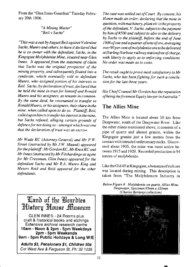
THE GRAFTON-MACLEAN METALLOGENIC MAP
The NSW Geological
Survey has compiled an extensive series of reports which can be used to assist
in the search for new mineral deposits or simply to locate existing ones. The
Grafton-Maclean Metallogenic Map group of documents may be downloaded from DIGS
(here) using this reference number: R00056102. The files take up about
65 MB and consist of many related documents apart from the map itself. These
represent the original report broken up into sections.
The map includes
the Torrington and Emmaville districts and extends southwards to Glencoe. The
western edge of the sheet joins the Inverell map, and it extends to the coast
in the east. The Inverell map will be the subject of a later blog.
The map provides a
vast amount of information – geology, structure and mineral deposits as well as
the underlying topography, roads, watercourses etc. This can make locating
something quite difficult and frustrating, so it’s important to become familiar
with the meaning of the colours and symbols provided around the margins of the
map. Here is an example of what the map contains:
The rest of the
documents in the downloaded folder provide information on the background
geology and the individual mineral deposits. Take, for example the deposit
number 1837, roughly in the centre of the extract. The table of mineral
deposits (left of map) describes this as “Back Plain Creek sapphire (Zr)”.
You
will find the deposit listed in the file titled
“Text_4.3MB_zip_of_4_deposit;_pdf” (the first of four of these). When the file
is open, scan through until you come to “GR 1837”, which is the extract below.
More
information can be found by looking up the Mineral Occurrence List in the
second part of the above file, using the same deposit number (1837).
You
could expand your knowledge of the area by searching other deposit numbers
nearby, whether you can find them on the map or not.
Another
possibilty is to search the Mindat data base (here) using the mine name.
This is what you will find for Back Plain Creek:
“Located
approximately 15kms NNW of Glen Innes.
Operated as a small open cut and shallow pits 1971 to 1990s.
Mineral List
2 entries listed. 1 valid mineral.
The above
list contains all mineral locality references listed on mindat.org. This does
not claim to be a complete list. If you know of more minerals from this site,
please register so you can add to our database.
This locality information is for reference purposes only. You should never
attempt to visit any sites listed in mindat.org without first ensuring that you
have the permission of the land and/or mineral rights holders for access and
that you are aware of all safety precautions necessary.
References
Metallogenic
Study and Mineral Deposit Data Sheets: Grafton-Maclean Metallogenic Map
(SH/56-6, SH/56-7), Geological Survey of New South Wales, 2001: HF Henley, RE
Brown, JW Brownlow, RG Barnes and WJ Stroud. Published by the Geological Survey
of New South Wales.”
Finally, you might
like to check out my blog on the Back Plain Creek area here.
Here is a link to a slide show of pictures from the data package: here.
All New England and other Geology blogs and videos
Limestone Caves of NSW
Song Studies. Bible studies based on hymns and songs
Shoalhaven District Geology.