Search This Blog

Showing posts with label gravel. Show all posts

Monday, 6 January 2014

“DOWN THE HILL” YARROW CREEK, NEAR GLEN INNES NSW AUSTRALIA

LIST OF ALL BLOG ENTRIES TO DATE

10.2 and 4.9 carat sapphires
Thanks to Google Earth. "Down the Hill" is in the centre
Many visitors to Glen Innes have enjoyed a day’s fossicking at “Down the Hill”, both on our Wednesday Baptist Church trips and during Minerama. I’ve written about the place in two previous blog entries (Quartz at Down the Hill and The Big Sapphire). Several videos have also covered the area (one, two and three). Click on the links to go there. 
                      “Down the Hill” lies downstream of “Through the Fence” and upstream of “Underground River”.

Down the Hill is an area with many rocky outcrops and, most notably, an abandoned channel through which the creek only flows in flood. At one time this was the most productive area, but the old diggings have mostly filled with sand and no-one seems too keen to spend the day removing it when they could search among the rocks. At the lower end of the channel the wash was at least two metres below the overlying sand. The last we saw of it, there was lots of black jack and    
Cliff O'Brien digging in the old channel 1998
presumably gems, but we were beaten by inflowing water and finally by a flood which filled up the hole with sand. Maybe one day, during a drought, fossickers will get another chance to experience the thrill of working this spot.
At some time, probably in the 1960’s, a small mining operation operated at Down the Hill. There was the remains of a shed or hut when I first visited the place in 1988 but hardly any sign of actual mining. This was on the flat immediately below where we parked. The only other sign of previous visitation was a Tamworth 1 pint milk bottle I found in the creek just below old hut site.
4.3 carat sapphire, 11.6 carat zircon (July 2008)
One day's small finds - December 2009
The gemstones are the usual ones for Yarrow Creek – sapphire, zircon, pyrope garnet, the occasional topaz and enstatite and, of course, quartz. My one and only cuttable ruby came from here, as well as my largest sapphire, best dog’s tooth crystal and biggest quartz 
0.3 carat ruby
Snowing July 2008
crystal. This is more a    reflection of the sheer quantity of wash we found than its superior  quality.
Snowing: July 2008 - the same day as the gemstone group above was found! July 2008

Sunday, 22 September 2013

ROCKY BEND, YARROW CREEK NEAR GLEN INNES NEW SOUTH WALES AUSTRALIA

ROCKY BEND, YARROW CREEK NEAR GLEN INNES 
NEW SOUTH WALES AUSTRALIA
Rocky Bend is a location which few of those who have come out on the Baptist Church Wednesday fossicking trips would ever have heard of. In fact, the last time we went there was in April 2007. The main problem was the distance we needed to walk from our cars. At Minerama that year it had been possible to get there in 4 WD vehicles but the track was basically non-existent and in any case conditions were drier than normal that year and we always had other good locations elsewhere on Yarrow Creek.
Readers need to be reminded that this is all private property. 

The site is about a 15 minute walk downstream from the Yarrow Creek bridge on the Mt Slow road. There is no gate. Keep to the left bank because the property boundary basically follows the creek. About 100 metres below the bridge the water is backed up by rocks at Rocky Bend so basically the creek is one continuous pool from there down. It’s my belief that the creek formerly flowed on the other side of a rocky ridge from near the bridge, but as that is on a different property this hypothesis is yet to be checked out.
Minerama 2007 find
A group effort at Minerama 2007
The main dig at Minerama 2007 was where the stream channel is choked with sand up against a large rock outcrop. Digging revealed lots of gravel, frequently embedded in white clay, and rich in black jack and gem stones. Keeping the sand out of the underwater hole is the main problem. There is a lot of good potential along this stretch of the creek.

My finds from the Minerama 2007 day


Tuesday, 9 July 2013

THE DUNDEE GRAVEL BEDS

THE DUNDEE GRAVEL BEDS

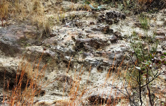
I first noticed quartz gravel in a road cutting on the Ranger’s Valley road near Dundee over 20 years ago. The location is 4.1km from the New England Highway, immediately before the road crosses the abandoned Wallangarra railway line.

For several hundred metres the road passes through low cuttings of poorly compacted sandstone containing layers of gravel. So far as
I have seen, all the pebbles are quartz and all are quite waterworn. Some are clear or smoky, but these make up only a few percent of the whole.

The obvious question is, where have they come from? The local rock is the Dundee Rhyodacite (locally called the blue granite).
It is a quartz deficient rock and I have not seen evidence of quartz veins in it anywhere. It is unlikely to be the source of the quartz pebbles.

The nearest major stream is the Severn River, which runs a km or so to the south. I haven’t seen gravel like this is the river but it is still possible that this outcrop represents an old course of the river. 

I believe that the most likely source of the gravel is the eastern end of the Mole Tableland in the vicinity of Stannum, about 30km to the north. Observations at Stannum reveal that a former stream bed vanishes beneath a younger flow of basalt. This is the classic “deep lead” situation and the Stannum Deep Lead has been traced beneath the basalt at least as far south as the Deepwater-Emmaville road. There are in fact up to 10 separate flows, which would have followed down the old valley, completely burying it and its alluvium.

Tin (cassiterite) has been mined from this gravel near Stannum, but the wash became less economic as it was traced southwards beneath the basalt. This is to be expected, as the cassiterite naturally became finer as it was carried further from its source. Not only that, but it becomes more difficult to locate the centre of the old lead beneath the basalt and most of the boreholes which were sunk missed the payable ground which might exist in the centre of the old valley.

The gravel at Dundee has no basalt cap, and the nearest outcrop of the Stannum basalt is a few kilometres to the north, but it is quite possible that it is part of the alluvium present in that ancient valley.

Reports on the Stannum Deep Lead mention zircon and spinel among the denser minerals found with the tin, but not topaz. I found no topaz when I carried about 20kg of gravel down to the Severn River and washed it. There was a residue of dense black sand which no doubt included cassiterite. Others have reported finding topaz here but this might have been clear quartz which is easily mistaken for it.

The easiest way to get specimens of clear and smoky quartz at this spot is to gouge out pebbles that look dark. Otherwise, if conditions allow, dry sieve the loose material and then wash it in a convenient puddle or take it down to the river. (The Severn River Road branches off the Ranger’s Valley road before you reach the cutting.)


A good reference is “The Stannum Alluvial Tin Deposits” by PL Rasmus, 1968 (DIGS GS1968/221).
 
Why not check out my You Tube channel here where you can view gem hunting, mining and general geology videos. New subscribers are always welcome.