KINGSGATE MINES Part 5
EXTRACTS FROM PREVIOUSLY PUBLISHED SOURCES
Annual Report of the Department of Mines, N.S.W. for 1882. pp 27-29.
"The formations here are granite and altered slate, forming rough broken country, with valleys about 500 feet deep. The line of junction is well defined and the bismuth lodes occur in the granite in proximity to this line or within about 400 yards from it.
The mode of occurrence of these so-called lodes is very remarkable; they are "pipe-veins" or oval masses of quartz of variable thickness, descending in a more or less vertical direction in the granite, as though well-like caverns of very irregular diameter have been formed in the granite and filled with quartz and metallic minerals.
Thus in one lode in the Kingsgate Company's property two masses of quartz (which the Manager, Mr. W. Yates, informed me were 30 feet apart at the surface), on being followed down, united and formed one large pipe-vein about 27 feet in diameter and of irregular shape, from portions of it protruding here and there into the granite. Nests of bismuth ore (native bismuth, sulphide, carbonate and oxide of bismuth) were obtained about these protruding portions as well as through the mass of quartz; and in order to take out the vein-stone a large excavation about 60 feet by 40 feet has been made.
The vein has only been sunk upon to a depth of 50 feet. The quartz is of a coarsely crystalline nature and contains, in patches, a considerable quantity of molybdenite. The metallic bismuth and sulphide occur in the solid quartz, but the carbonate and oxide lie chiefly in the joint fissures in the quartz.
Sometimes masses of native bismuth are found between crystals of quartz in the vein, and when removed the impress of the quartz crystals is well shown. Some splendid specimens, from 4 to 6 lbs. in weight, from this mine were presented by the company to the Mining and Geological Museum; some of them have been forwarded to the Amsterdam Exhibition.
The largest mass of native bismuth found here weighed nearly 30 lbs.
Other similar veins, but smaller, have been proved, though only for a few feet in depth; one contains much arsenical pyrites and hexagonal plates of molybdenite. An average sample of these sulphides gave on assay metallic bismuth, 2.6%, fine gold, at the rate of 8 dwts per ton, silver, at the rate of 3 ozs, 5 dwts per ton.
Several veins of a similar nature have been opened at the Glen Innes Company's property, which adjoins that of the Kingsgate Company. The Company is now sinking upon a vein which is said to have been 1 foot wide at the surface, but when I saw it at a depth of 40 feet, the lowest level then reached, it was 4 feet wide. This vein is in granite, and close to the boundary of the slate formation. The vein stuff is thickly studded with large brilliant steel-grey plates of molybdenite, some of them being more than 3 inches in diameter. Nodules of native bismuth, larger than walnuts, with carbonate, sulphide and oxide of bismuth, occur through the vein, and in greater quantity in places where the molybdenite becomes abundant.
Some of the lodes at Kingsgate were originally taken up in 1871 for tin mining, but it is said that J. Feeney, a stockman on Yarrow Creek Station, was the first discoverer of the bismuth, in the year 1877. I am informed that the quantity of bismuth ore raised from these mines during the last four years is about 40 tons. Hitherto the vein-stuff has been very imperfectly treated by hand-crushing and washing, and there is no doubt that by this crude process much of the fine oxide and carbonate of bismuth have been lost. It will always be a difficult matter to save these ores, when they are in a fine state of division, by the simple process of "streaming" or washing. In my opinion reduction furnaces should be used.
The Kingsgate Company is now cutting a long race for bringing water from the Yarrow Creek to the mines for the purpose of washing the ore on a large scale. When efficient appliances have been introduced for the treatment of the ores I believe that the bismuth mines of the district will become of considerable importance."
ditto, p77 “Two local companies hold all the land in which this metal has been found in payable quantities at Kingsgate, but beyond sinking trial shafts and raising sufficient ore to pay current expenses nothing has been done to place the industry on a permanent footing. The Kingsgate Bismuth has I believe entered into an agreement with some Sydney capitalists to transfer their rights in the mines on an early date, and the bulk of the purchase money has been paid.
On completion of the sale, and when in the hands of the new and wealthy proprietary it is reasonable to suppose that greater energy will be brought to bear in developing what appears to be a valuable property. The Glen Innes Company possesses an equally rich tract of mineral land, but as in the former case operations at this mine are hindered by the want of sufficient capital to carry the initiatory proceedings to a successful issue.
The native bismuth forwarded by me to the Department for transmission to the Amsterdam Exhibition was obtained from pockets in the quartz matrix at this place, but usually the ore is more evenly disseminated through the lode. One parcel of ore from this mine showed under assay by the Government Analyst 123 ounces of silver to the ton.
Account sales of bismuth ore in London are of too conflicting a character to be quoted as determining the value of the material in the home market."
Annual Report of the Department of Mines, N.S.W. for 1887 p88.
"It is very difficult to obtain reliable data on which to found an estimate of the output and value of this metal, as the manager of the only mine actually at work (the Kingsgate), acting under instructions from his principals, declines to give any information on those points.
A personal inspection of the mine early in January showed me that 40 men and 20 boys were at work at various shafts and tunnels on the company's lands, and that a large amount of excavation had been effected during the year in searching for the mineral. The ore is not found in fissure lodes, as is usually the case with other metals, but in irregular shaped cavities termed "pipes", which have been followed downwards in the granite rocks to a depth in some instances of 100 feet.
The ore is roughly broken, hand-picked, and worked before being bagged for shipment to England, and averages about 50% under this treatment.
According to the railway returns, 35 tons 9cwt. 1 qr. 25 lbs were forwarded during the year to Newcastle; and I believe this to have been about the output of the mine for the past twelve months.
At the adjoining (Glen Innes) mine, very little work has been done, in consequence, I believe, of a want of sufficient capital; but it is to all appearance as rich in bismuth as its neighbour, and is said moreover to contain some valuable ores of silver.
The country is generally of coarse granitic formation, overlaid in places with a thin crust of basalt. The bismuth-bearing granite rock is well defined, and cut off on the north, east and west by a broad belt of slate, beyond which in those directions none of that metal has been found."
Annual Report of the Department of Mines, N.S.W. for 1918 pp 52-53.
"The principal mine is that now worked by the Kingsgate Molybdenite No Liability. This was, in February, acquired from Mr. W.H. Yates, and is one of the biggest producers of molybdenite and bismuth in New England. Whilst held by Mr. Yates (up to 5th February 1918) 11 tons 3 cwt. of molybdenite ore were raised, valued at £1 454, and 2 tons 12 cwt. of bismuth were won, valued at £992.
Operations were carried out by the new company from the 5th March to the 25th October, 1918, and during that time 1 018 tons of molybdenite valued at £2 112 13s 5d, also 7.5 tons of bismuth, valued at £2 288 . Forty five men are employed on this mine. There are fifty-four known and proved pipes on this property containing molybdenite and bismuth, the majority of which have not yet been worked.
The value of the old mill is estimated at £2 000, but active mining operations have ceased and a new milling and mining plant (estimated to cost £14 000) is now in the course of erection and should be operating in April, 1919. The new mill will comprise a No 1 Dodge breaker, 25 X 14 rolls, May Brothers jig, four Wilfley tables, two forward down grinding pans, two vanners, an eight-cell minerals separation flotation plant, and a one-cell mineral separation subaeration machine. The power will consist of two 100 H.P. multitubular boilers, one 165 H.P. Davy Paxman cross compound steam engine, one 35 H.P. Tangye engine with electric generator and motors. The mining plant will consist of a 14 in. X 12 in. belt-driven Ingersoll-Rand compressor, four jack hammer drills and one stope-hammer drill. One and half miles of 3.5 in., 2 in., and 1.5 in. pipe line for compressed air mains is now being laid for drilling, hauling, ventilating and pumping.
It is proposed to mine 75 tons of pipe material per day, and by hand picking or sorting reduce it to 25 tons per day for milling purpose.
The Glen Innes Molybdenite and Bismuth Syndicate. This syndicate are the holders of a lease of 25.5 acres, being portion of mineral lease 45 at Kingsgate. Practically no work has been carried out during the year as the syndicate have exhausted their capital, but an attempt is being made to raise further capital to enable them to continue sinking in an endeavour to obtain the rich pipe formation which was lost some years ago.”
Annual Report of the Department of Mines, N.S.W., for 1920 p34.
"The Kingsgate Molybdenite Co. treated 2 294 tons of pipe formation for a return of 8 tons 15 cwts of molybdenite concentrates valued at £4 370. Machinery to the value of £24 000 has been erected by this company. The deposits at Kingsgate rank among the richest in the Commonwealth and occasionally heavy masses of the mineral are found in a solid formation in the pipes.
The Glen Innes Molybdenite and Bismuth Syndicate won £120 worth of molybdenite during the year. A.A. Veness and party treated 60 tons of ore for a return of 16 cwt. valued at £408. Marshall and party raised 100 tons, 40 tons of which yielded 7 cwt 3 qrs. of molybdenite valued at £141. Other owners produced smaller quantities.”
Annual Report of the Department of Mines, N.S.W., for 1921 p 34.
"There has been no production of molybdenite during the year as there has been no sale for the mineral."
Annual Report of the Department of Mines, N.S.W., for 1948 p 29.
"During the year, J.W. Webster drove a tunnel some 120 feet to cut a bismuth pipe some 75 feet below its outcrop. At the end of the year the tunnel had not reached the pipe. E.E. Moscovits pumped out a number of bismuth bearing pipes on the south end of the field. During the coming year he expects to proceed with mining operations and the erection of a treatment plant."
Department of Mines, N.S.W. - Geological Reports 1939-1945. p 80.
"The Kingsgate deposits are situated about 20 miles east of Glen Innes. Quartz pipes formerly worked for molybdenite and bismuth have yielded a small amount of quartz suitable for radio-communication purposes.
Since the outbreak of war a considerable amount of work has been done by M.W.J. Priest, on behalf of Amalgamated Wireless (Aust.) Ltd. and by J. Webster. To date Priest has recovered approximately 400 lbs weight of suitable crystal, principally by turning over the dumps on the "Old 45" lease. Webster's production is not known.
The Arsenic Shaft on M.L. 45 has been unwatered and reconditioned. Mining operations are now being carried out on the quartz pipe disclosed.
An old shaft approximately 60 feet deep on pipe No. 44 situated on Block 41 has been cleaned out and mining operations are now in progress. A small quantity of suitable crystal has been obtained from this shaft.
The Water Cut (Wet Shaft) on M.L. 45 parish Kingsgate is now being unwatered with aid from the Prospecting Vote. Perhaps the best samples of crystal recovered so far came from the dumps from this shaft.
It would appear that there are prospects of obtaining supplies of suitable crystal from the Kingsgate deposits, but it cannot be too strongly emphasised that the proportion of usable material will be very low and that mining costs will be very high."
The Molybdenum Industry in N.S.W. by E.C. Andrews (N.S.W. Department of Mines, 1916) p 9.
A description of W.H. Yates' treatment plant in 1915. "The capacity is about 5 tons a day, and the cost of the plant erected was about £1 000. Two men and a boy are employed on the plant.
Ore with an average content of 3% bismuth and molybdenite is handfed from a plat to a No. 2 Dodge rockbreaker, and there crushed to pieces about 1 inch diameter. From the rockbreaker the ore passes through two sets of rollers, each having screens to save the large flakes of molybdenite as over-size. This over-size is re-rolled to reduce the quartz to a smaller gauge. Underneath the second pair or rolls a shaking screen is fixed. The holes in this shaking screen are about 1/12 inch diameter. The under-size passes on to a Wilfley table to save the bismuth, the tailing being stored pending probable improvements in treatment, such as some form of oil concentration.
The over-size from the 1/12 inch screen is carried to a third set of rolls where it is crushed to 1/20 inch gauge, and screened. Much of the over-size from this process is cleaned by hand-sieving. The first part of the over-size, however, is recrushed in rolls set close together, and passed over screens of 1/32 inch mesh. The over-size from this varies from 92-95% molybdenite. The under-size is a product rich in molybdenite, but considered below 90% fine.
A plant of type similar to this but costing, according to report, about £1 500, has been erected by the Glen Innes Molybdenite Mining Company on the Old 45, or Sachs' lease. A similar plant belongs to the "Sachs of Kingsgate" Company."
Ditto p9. A Description of a Typical Pipe.
"If such a pipe be examined in cross-section from footwall to hanging wall it would be found that the granite country has been altered just below the footwall, the felspars being replaced by nests of hydrous mica, while in the footwall itself whole masses of this mica, soft and yellowish in colour, may be found. Granite would also be found in which the felspars had been replaced, first by certain products, then by mica, and this mica, in turn, by quartz, the original granite having been changed at this stage to a tough and granular quartzite.
The footwall of the pipe would consist typically of tight, granular, and interlocking quartz, of a dark colour, containing grains and massive crystalline native bismuth. Above this the quartz would be tight, dark and massive, with numerous small vughs showing portions of crystalline quartz, with bismuth and molybdenite. Above this much cairngorm is developed, typically crystalline in many places, and carrying little bismuth. Above this again, massive and crystalline quartz is commonly found. The quartz may be white, massive and brittle, or it may be in the form of huge crystals whose pointed ends project into large cavities. Quartz crystals also may lie in the cavities or may occur in the solid massive quartz. These crystals may vary in weight from a fraction of an ounce to £300 or £400, while they occur as forms closed by pyramids or points at both ends. The cavities mentioned here may be as much as 12 to 20 feet in length and several feet high besides being of considerable width. The hanging wall consists generally of massive quartz containing nests of secondary mica which in many places is clearly a replacement of the felspar of the country rock."
Ditto p98 - The Molybdenite Bonanza in the Old 45 Pipe.
"Mr. Valentine Sachs secured a lease of the No. 45 Block, and he commenced to send ore to Sydney in 1902 from the pipe, the ore being carted along the private road through the Kingsgate Freehold.
A large and rich patch of molybdenite and bismuth ore was found by Mr. Sachs at a place where the pipe had been enlarged considerably. One very large piece of pure molybdenite was found in the great chamber excavated in the enlargement. The piece exceeded one ton in weight and had to be torn in pieces before it could be brought to the surface. A chamber about 60 feet in length, with a width and height varying from 12 to 25 feet, was excavated in the enlargement, and many tons of molybdenite were won therefrom.
The continuation of the pipe was lost, however, by Mr. Sachs, and after an eventful history the mine was acquired in 1912 by the Glen Innes Molybdenite and Bismuth Company; and in the same year the company known as the "Sachs of Kingsgate Molybdenite and Bismuth Syndicate" took up a lease for mining over a road lying between Mr. Yates freehold and the Glen Innes Molybdenite and Bismuth Company's lease.
The newcomers experienced great difficulty in finding the continuation of the 45 pipe below the great chamber excavated by Mr. Sachs. It was found, however, to have suffered a local constriction, the quartz immediately below the chamber not exceeding 18 inches in diameter and having a vertical direction."
Ditto p 110.
"Mr. Hagen, manager for the company, made a careful examination in directions generally towards the claystone or slate in the vicinity. He actually cut the claystone in one place within a distance of 18 feet from the "hanging wall" of the deposit near the base of the old rich chamber. The floor of the chamber was then cleaned out and a bunch of quartz exposed therein about 18 inches in diameter, according to the statement of Mr. Hagen. This was then followed in a vertical direction for a depth of 30 feet, the size of the deposit being 4 or 5 feet in diameter, at a depth of a few feet below the chamber. Thence it was followed easterly for a distance of 25 feet along a very slight slope. At this point the pipe was still small, and it was followed thence in a vertical direction for a distance of 15 feet, where it appeared to split into two, each branch being small, one directed towards the north-north-east at a steep angle and the other towards the east first and then south-east at a steep angle.
The workings are approached by a tunnel about 100 feet in length, which intersects the pipe at a depth of 30 feet approximately below the outcrop in a vertical direction. The pipe in this upper portion dipped at an angle of 45 degrees, thence, for a distance of 50 feet, in a direction south-south-east it had a negligible slope, while beyond this division for a distance of about 100 feet or thereabouts, the pipe maintained a direction, generally easterly, at a slope of about 1 in 2 (26 degrees).
In the lower portion of this underlie the great chamber was excavated, from which the rich body of molybdenite and bismuth was won."
Molybdenum in N.S.W. (N.S.W. Department of Mines, 1978) pp 53-55.
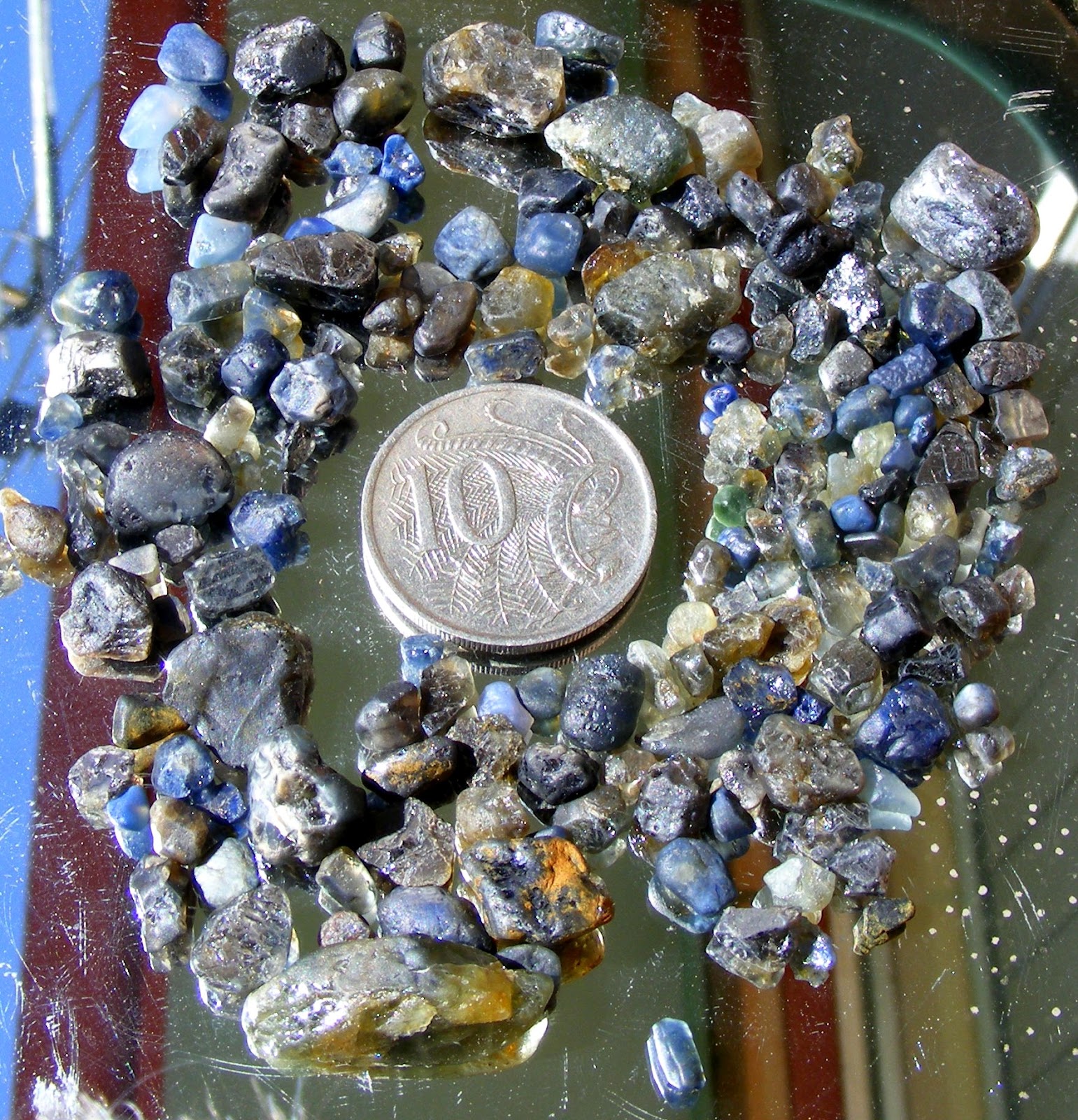
"The famous Kingsgate pipes have yielded more molybdenum than any other deposits in the state. Indeed, Kingsgate is second only to Wolfram Camp, Queensland (also pipes), in molybdenite production in Australia. Total production of concentrates is approximately 350 t molybdenite, 200 t bismuth and 12 t wolframite-bismuth. Much of the ore was found as small bonanzas in a few of the pipes, of which No.45 (Sachs') is the most famous. One mass of pure molybdenite from this mine weighed more than a tonne. The mines at Kingsgate were opened in the early 1880's. They declined after the late 1920's.
During World War 11, piezoelectric quartz, used in radio equipment, was mined from the pipes. There has been no production since 1951.
Some seventy pipes have been found, of which fifty-four have been productive. They are located in a 3 km long belt trending a few degrees west of magnetic north. All the pipes occur within the granite and near its contact with the sediments. The sediments lie to the east of the deposits, and the intrusive contact dips to the east at 20o - 30o, that is, away from the pipes. In plan, nearly 95% of all pipes are within 300m of the contact. Prior to erosion, the true distance of all pipes from the contact may have been even less.
The pipes vary from 15m to more than 150m in length, and in diameter from 1m to 20m. The most common diameter is in the range 2 - 8m, but a uniform diameter is rarely maintained for more than 30m. The direction and angle of plunge of pipes, although quite variable, tend to parallel the granite contact (20o - 30o towards the east), but all variations from flat to vertical also occur. Only a few pipes have been worked for more than 75m downslope. There is no authentic case of a pipe having completely died out at depth, but work often ceased when the pipe dimensions narrowed and the pipe's tortuous course introduced difficulties in servicing beyond the capacity of the operators."
The Mineral Deposits of N.S.W. (N.S.W. Department of Mines, 1974) p 360.
"The origin of these and all the other pipes in the block is still a matter of conjecture. C.S. Wilkinson (according to Andrews 1916) held that the granite developed cavities near its margin as a result of contraction upon cooling at a relatively rapid rate. Two unsatisfactory aspects of this theory are firstly that it does not explain the pipe-like shapes and secondly it could be argued that homogeneous granite, on cooling, would produce joints. Andrews (1916) himself postulated that the pipes were formed by the action of hydrothermal solutions, which arrived by planes of weakness and acted strongly upon the host rock, producing alteration and replacement. However, the nature of the planes of weakness is unexplained and they are not in evidence today. (Observed joints, as stated appear to post-date the pipes). Lawrence and Markham (1962, p72) considered the pipes to be intrusive in origin and to represent "an ultra acidic final magmatic differentiate" of the acid granite host. They believed that "there may be no structural control in the sense of a predetermined access", and likened the pipes to chonoliths. Lawrence was quoted by Nicholson (1966) as having suggested that the intrusion may have taken place prior to the complete crystallisation of the granite. This third theory, too, does not account for the pipe-like shapes of the bodies."
All New England and other Geology blogs and videos
Limestone Caves of NSW
Song Studies. Bible studies based on hymns and songs
Shoalhaven District Geology.