Search This Blog

Showing posts with label deep lead. Show all posts

Friday, 22 July 2016

TOPAZ LOCALITIES WEST OF TORRINGTON NSW AUSTRALIA

TOPAZ LOCALITIES WEST OF TORRINGTON NSW AUSTRALIA

In this blog I’ve attempted to bring together a list of all the places where topaz has been reported to the west of Torrington, in the New England region of NSW. So as not to repeat a lot of what I’ve already written, I’ve given references to some of my articles (in John’s New England Minerals blog). In some cases the reference to topaz may be very minor.
Please note that many of these locations are on private property and you will need permission from the owner to enter.
There are a number of useful references you can download. Firstly, there is the Minerama booklet “Topaz” (here). This gives information and references on many topaz localities in the New England region. (You will need to search Google to find a downloadable copy of this booklet. In searching use topaz book Minerama 1995 as key words. It appears later in this Blog.

Secondly, there is Edgeworth David’s report on the Vegetable Creek Tin Field, published in 1887. It contains an amazing amount of information on what is still a pretty remote part of the country. At the time the report was compiled, only 50 years had passed since the first Europeans entered the district. You will need to go to DIGS (here). The reference number R00030528 will bring up a PDF of a 2 page map which is invaluable in locating old mines and workings. The same map, but on a single page this time, is at the very end of the report itself, for which the reference number is R00031676.

Thirdly, there are the Grafton-Maclean and Inverell metallogenic maps and data sheets, which are comprehensive reports covering all significant (and often insignificant) mines and mineral deposits, with lots of geological and mineralogical details. The respective DIGS reference numbers are R00056102 and R00050906 .

Fourthly, there is the mineral data base Mindat (here), where searching can often bring up information on a particular location. Much of this has been extracted from the previously mentioned reports.
Here are the links to areas already covered in my Blog:
Scrubby Gully topaz
Gaden’s Lode Gulf Road Emmaville (here)
Specimen Hill, The Gulf Near Emmaville (here)
The Gulf Fluorite Mine Near Emmaville (here)
Scrubby Gully, Torrington (here)
Surface Hill Gem Deposit Gulf Road Emmaville (here)
The Emerald Mine, near Emmaville (here).
These are well known localities, which have been visited by collectors and gem hunters for many years. This is not to say that there is nothing of interest left, on the contrary we continue to hear of attractive (and sometimes valuable) specimens being found in these places.
Fossicking at Surface Hill
West of the Beardy River, and entirely on the Inverell 1:250000 sheet, David reported the existence of numerous alluvial tin deposits, many of which are “deep leads”, lying beneath the extensive basalt flows which cover much of the area. I haven’t heard of anyone looking for gems in the area, but David’s descriptions mentions them several times.
The familiar ones are at Scrubby Gully and Surface Hill (both east of the Beardy). Links to my blogs on these are given above. That the topaz, beryl etc at SG and SH have originated from pegmatites around the edges and roof of 
Cross section of a lead (David)
the Mole Granite is beyond doubt. The same is most likely to be true of the deposits listed below. These gem bearing alluvials are probably derived from sources which have long since eroded away.
All these quotations are from David.
The Kangaroo Flat Lead. Details are on pages 93-94. The location is to the west of  Emmaville. “near the north-east corner of Portion 45, Arvid, at the Avoca Mine near the north-east corners of 104 and 105 in the same parish.” “The gravel averages 2 feet in thickness, and is composed principally of flattish, oval pebbles of claystone 2-3 inches in diameter, and well-worn pebbles and grains of quartz; and gem-stones, as green beryl, emerald, sapphire, topaz etc and fine grains of stream tin chiefly black.”
Hall’s Sugarloaf. Details are on page 95. “Half a mile south-west of Foley’s is Hall’s Sugarloaf, a
small outlier of basalt capping stanniferous gravel.” “The deposit may be described as a “cement” consisting of pebbles of claystone 3 inches in diameter with small well worn quartz pebbles, quartz sand, and small gems, as topaz and beryl, set in white and grey pipeclay, which has been baked in places into a tough natural brick.” Quite a few other mines in the area are also described, but no mention is made of gemstones. I think we can safely assume that gems are present in the wash at these places.
The Rocky Creek Lead. “The tertiary country embraced under this name extends from Cockatoo to the water-parting between the Severn and Dumaresq Rivers in the parish of Lorne, a distance of 9 miles.” “At the Basalt Hills the gravel has been tested by several shafts and two tunnels. The alluvial beds are composed chiefly of fine quartz sands such as results from the waste of quartz-porphyry (containing a number of beryls), with pebbles of claystone up to 1 inch in diameter.”
“The Gem Lead has been proved to be a rich feeder, falling into the main body of basalt from the north-east.” “The commencement is in an outlier of quartz sand and gravel, capped by basalt in portion 38, Lorne.” “The richest yield here was 3 tons of stream tin from 70 cubic yards of wash. Emeralds and sapphires are associated with this stream tin.”
The Ruby Hill Lead. “The width of the volcanic formation varies from 5 chains to 2 miles.” “Constituents of the gravel are well rolled pebbles of clear and opaque quartz, red and black jasper, and pebbles of quartz-porphyry, the last attaining the diameter of 1 foot. Zircons and sapphires are plentifully intermixed with the stream tin.”
Beginning on page 164 David gives a summary of gems found in the Vegetable Creek area.
I would be delighted to hear from anyone who makes gemstone discoveries in this area. The comments area below can be used.

Friday, 2 January 2015

SURFACE HILL GEM DEPOSIT GULF ROAD EMMAVILLE

SURFACE HILL GEM DEPOSIT GULF ROAD EMMAVILLE

Location of Surface Hill with the basalt outliers marked
 How often have you wished you were around in the “good old days”? It must have been easy to pick up gemstones then. Maybe.
“Australian and New Zealand Gemstones” (1972) by Bill Myatt has this statement on page 298 in a section about Emmaville. “The Gulf Road is not good in rainy weather, as it crosses four creeks; the crossings, however, are all cemented. Sixteen miles out, Bill Frappell’s Topaz Farm is on the left, where camping and fossicking is allowed on payment of a fee, the money going to charity.” I don’t know when this arrangement ceased, but I would guess more than 30 years ago.

The place we are talking about is correctly called Surface Hill. If you’re searching for information, don’t get confused with the many other Surface Hills around, especially the one on the Timbarra goldfield near Tenterfield. The name refers to the fact that the alluvial wash there was on the surface of the ground rather than in a creek bed or its banks. The place is about 2 km south of the Gulf Road, between Flagstone and Little Flagstone Creeks. Both Minerama and Emmaville Gemfest have conducted field trips there. The last I knew, it was part of the property called “Willow Creek”, where James and Kerry West conducted their business “The Fruit Salad Tree Company” (multi-grafted fruit trees). I believe the property has recently been sold.

Naturally, the old time miners were not interested in topaz. They were after tin (cassiterite) which was eagerly sought all over the Emmaville and Torrington districts from 1872. The cassiterite originated in fluids associated with the nearby crystallising granite. There are literally thousands of veins, dykes and impregnations which formed from the early Triassic Mole Granite. Some are within the granite itself, others are in the adjacent intruded rocks, such as those at Webb’s Silver Mine. At the Emmaville Emerald Mine, the pegmatite dykes can be traced from the intruded rocks into the granite itself.
From TWE David. Basalt outliers marked
The story at Surface Hill is entirely different. Here the cassiterite is found as waterworn grains in an old stream deposit. Let me quote TWE David (from his 1887 report on the Vegetable Creek Tin-Mining Field, DIGS reference R00031676, page 45): “The Tertiary gravels at Surface Hill form three outliers. At Surface Hill a flat-topped ridge of claystone is capped by a bare oval patch of tertiary gravel. The deposit has an extent of 1 acre and a thickness of 1 to 2 feet. The pebbles of which it is composed are principally quartz, from 1 to 6 inches in diameter, and as smooth as eggs. A great deal of tourmaline, as well as topazes, beryls, emeralds, and stream tin (alluvial cassiterite ed), are mixed through these gravels, which from their higher position appear to be older than the similar gravels underlying  two neighbouring outliers of basalt. In its lithological character, and in its stratigraphical relation to the “deep leads” this small outlier of gravel closely resembles the tertiary pebble beds at Cope Hardinge, near Tingha. The importance of these outliers rests not so much on the minerals contained in them, though that has been considerable, as on what they teach of the former wide distribution of stream tin deposits in early tertiary time. The gravels at Scrubby Gully and Surface Hill are over 6 miles distant from one another, the former being 3,360 feet above sea level, and the latter 2,460 feet; while those in the Ruby Hill outlier have an altitude of 1,885 feet, and are over 25 miles distant from Scrubby Gully.”

The mention of topaz, beryl and emerald should get any self-respecting fossicker’s heart racing. I’ve been out to Surface Hill a few times and never failed to find topaz, though not the other minerals. I have no doubt that this is because of the similar specific gravity of beryl to quartz: We look for topaz in the sieve centre because it is dense but forget the less dense beryl among the quartz fragments. It is the same story at Blatherarm and Scrubby Gully. You won’t find alluvial beryl unless you are looking for it.

David has more to say on page 164. “Beryl occurs most frequently in small waterworn round or oval prisms from ½ to 1 ½ inch long and from 1/8 to ¼ inch thick. The localities where it is most abundant are Surface Hill and Kangaroo Flat. The majority of specimens are pale green, and many are colourless. The gems generally contain a number of minute cavities, which of course detract immensely from their value. Some specimens from Kangaroo Flat, which have been cut and polished, are valued at about £4, the cutting and polishing having cost about £3.”  
The only other major source of information on Surface Hill I’ve been able to locate is in the Grafton-Maclean Mine Data records (DIGS Reference R00056102). There are two listings: Surface Hill Northwest (GR1012) and Surface Hill (GR1039). The descriptor for both is “Sn, topaz – industrial fossil placer (fluvial)”.
The 1906 SMH report
Surface Hill Northwest pretty well matches TWE David’s description; there is both a surface deposit and a deep lead under a small basalt cap. A large race carried water to work the gravel which is dated to A Bouveret in 1883. NOTE. The two dams on the creek running south and the existing water race from the creek could date from E Sturtridge’s work in 1906, which is not mentioned. See the Sydney Morning Herald note for 30th June 1906 (here).
Surface Hill proper is a deep lead deposit with workings dating from 1878. To quote: “Numerous shafts and pits on side of hill. Wash around shafts has rounded white pebbles of quartz. Has known association with blue topaz and alluvial cassiterite.”
What would you see if you were able to get permission to go out there? Firstly, I suggest that you follow the water race from the creek and see where it goes. This is Surface Hill Northwest. All the topaz and beryl would have been discarded where the gravel was washed. The area where the surface gravel was removed is where I picked up numerous piece of topaz in 2001 solely because of the glint of the sun from cleavage faces. Find where the deep lead was mined.
The track continuing around the hill without crossing the creek should go to the main Surface Hill deep lead workings. Once again, beryl and topaz should be in any discarded gravel piles or in the gully where water carried away the waste.
This link here will take you to the ALF thread on Surface Hill, from which I “lifted” Wwoofa’s photograph below.

Field Trip to Surface Hill. Photo "Wwoofa", Australian Lapidary Forum

Tuesday, 9 July 2013

THE DUNDEE GRAVEL BEDS

THE DUNDEE GRAVEL BEDS

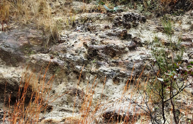
I first noticed quartz gravel in a road cutting on the Ranger’s Valley road near Dundee over 20 years ago. The location is 4.1km from the New England Highway, immediately before the road crosses the abandoned Wallangarra railway line.

For several hundred metres the road passes through low cuttings of poorly compacted sandstone containing layers of gravel. So far as
I have seen, all the pebbles are quartz and all are quite waterworn. Some are clear or smoky, but these make up only a few percent of the whole.

The obvious question is, where have they come from? The local rock is the Dundee Rhyodacite (locally called the blue granite).
It is a quartz deficient rock and I have not seen evidence of quartz veins in it anywhere. It is unlikely to be the source of the quartz pebbles.

The nearest major stream is the Severn River, which runs a km or so to the south. I haven’t seen gravel like this is the river but it is still possible that this outcrop represents an old course of the river. 

I believe that the most likely source of the gravel is the eastern end of the Mole Tableland in the vicinity of Stannum, about 30km to the north. Observations at Stannum reveal that a former stream bed vanishes beneath a younger flow of basalt. This is the classic “deep lead” situation and the Stannum Deep Lead has been traced beneath the basalt at least as far south as the Deepwater-Emmaville road. There are in fact up to 10 separate flows, which would have followed down the old valley, completely burying it and its alluvium.

Tin (cassiterite) has been mined from this gravel near Stannum, but the wash became less economic as it was traced southwards beneath the basalt. This is to be expected, as the cassiterite naturally became finer as it was carried further from its source. Not only that, but it becomes more difficult to locate the centre of the old lead beneath the basalt and most of the boreholes which were sunk missed the payable ground which might exist in the centre of the old valley.

The gravel at Dundee has no basalt cap, and the nearest outcrop of the Stannum basalt is a few kilometres to the north, but it is quite possible that it is part of the alluvium present in that ancient valley.

Reports on the Stannum Deep Lead mention zircon and spinel among the denser minerals found with the tin, but not topaz. I found no topaz when I carried about 20kg of gravel down to the Severn River and washed it. There was a residue of dense black sand which no doubt included cassiterite. Others have reported finding topaz here but this might have been clear quartz which is easily mistaken for it.

The easiest way to get specimens of clear and smoky quartz at this spot is to gouge out pebbles that look dark. Otherwise, if conditions allow, dry sieve the loose material and then wash it in a convenient puddle or take it down to the river. (The Severn River Road branches off the Ranger’s Valley road before you reach the cutting.)


A good reference is “The Stannum Alluvial Tin Deposits” by PL Rasmus, 1968 (DIGS GS1968/221).
 
Why not check out my You Tube channel here where you can view gem hunting, mining and general geology videos. New subscribers are always welcome.