Search This Blog

Showing posts with label zircon. Show all posts

Sunday, 24 March 2024

  WHERE ARE SAPPHIRES FOUND?


                                   pyrope, sapphire and zircon from Yarrow Creek

There are two kinds of gem deposits in the Glen Innes area: Primary and Secondary or alluvial. 

The primary deposits are those containing the gems in the original rock or weathered material formed from it. The secondary deposits are concentrations found in present day streams, abandoned stream channels and deep leads or buried stream channels. 

The only primary deposits the casual fossicker is likely to meet are at the DeJon mine on the Gwydir Highway at Elsmore and at the Wellingrove Fossicking Reserve.


                                                      Quarry at DeJon mine

At the Wellingrove Reserve, there is no sign of the overlying basalt, though it is visible in road cuttings just before the turnoff into the Reserve. The sapphires are found in reddish clay overlying the Wellingrove granite. This clay is evidently the weathered remains of volcanic material ejected over the area immediately before the outpouring of the basalt. Fossickers will soon notice the absence of typical water worn sand and pebbles in the so-called "wash". The greatest concentration of gems is in the bottom few centimetres of clay, which may be buried beneath several metres of soil.

 
            Wellingrove wash and granite boulders

Alluvial deposits are found in stream beds all over the district. The major requirement for finding concentrations of gems is to be searching in an area where there are outcrops of bedrock in the creek to act as traps. Otherwise the dense gemstones will be buried deeply in the gravel and inaccessible to the casual fossicker. This rules out most of Reddestone, Wellingrove and Furracabad Creeks and the Beardy Waters. In other places, it's necessary to think of how the water behaves in a major flood, because this is the only time the dense gemstones are actually shifted. They will then be deposited in places where there is a sudden decrease in stream velocity such as in the lee of boulders, below rapids etc. These are the places to identify and search for the best results.


     Where Do Sapphires Come From?


Throughout NSW and Queensland, sapphires are nearly always found in areas where basalt rock has been eroded. Occasionally one turns up in a basalt floater (loose piece of solid basalt) or in soil overlying basalt rock and clearly formed from it by weathering. 

It's believed that some sapphires are found throughout the extensive basalt lava flows of New England, brought up from deep within the Earth by rising magma some 37 million years ago. The result is that almost every stream between Glencoe and Dundee, Glen Elgin and Inverell holds its quota of marvellous blue, green, yellow and particolour sapphires.


                                  digging for gravel in Yarrow Creek

                                                 Sapphires from Rainy Swamp
Investigations at Elsmore and in the Kings Plains and Wellingrove areas suggests that the greatest concentration of sapphire and the other dense minerals is in volcanic ash beds which lie below the first great lava sheets. These are the product of the explosive activity which took place when the volcanic cycle commenced. Weathering of these rocks has released the precious stones to be concentrated in modern creeks and ancient deep leads by virtue of their greater hardness and density. 

The distribution of sapphires suggests that other explosive centres may have been located near Mt. Slow, Glencoe, Furracabad and Bald Nob. The search is on to locate sapphire bearing rocks in these places. If these deposits prove to be economic, Glen Innes will be a source of precious stones for hundreds of years to come.

   Minerals Found in Gem Gravels. 

The process of concentration which takes place during sieving should separate out all the dense minerals found in the wash. The other materials, mostly pebbles of various rocks and quartz (as worn

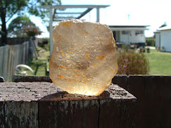
                                                 Smoky quartz Yarrow Creek


          quartz from Garnet Corner

crystals and vein fragments) have specific gravities between 2.5 and 3.1.  That is, they are 2.5 to 3.1 times denser than water. Of these, only some of the crystalline quartz is likely to interest the fossicker.

 The denser minerals, with their specific gravities, are as follows:   

               corundum (sapphire & ruby)    4.0                                                       pleonaste (black spinel, commonly called blackjack)   4.1               zircon    4.7                                                                                            garnet (most often pyrope)  3.5-3.7                                                        topaz   3.4-3.6                                                                                         enstatite  and hypersthene   3.2 - 3.5       

              tourmaline (the black schorl variety)   3.0 - 3.3                                    cassiterite   6.8-7.1                                                                               "ironstone" (ferruginous bauxite)  2.5 - 4.0                                                   depending  on the iron content. 

Not all of these will be found together. The typical sapphire concentrate will consist of ironstone, corundum, zircon, garnet and pleonaste; less commonly topaz and enstatite will turn up. Tourmaline and cassiterite can be expected in tin areas around Backwater, Tingha, Emmaville and Torrington. 

 How to Recognise the Various Minerals. 

Nothing beats being shown by an expert, but it is comparatively easy to distinguish the various minerals.  Ironstone is opaque, reddish brown to black which crushes to a red powder.  Pleonaste is invariably found with sapphire in New England. It is black and lustrous and occasionally confused with corundum, especially on bright sunny days.

                                        Pleonaste (spinel, blackjack) Rainy Swamp

 Corundum is the mineralogical name of the mineral whose transparent varieties include ruby and sapphire. The name ruby is reserved for the red variety of corundum, all other colours being
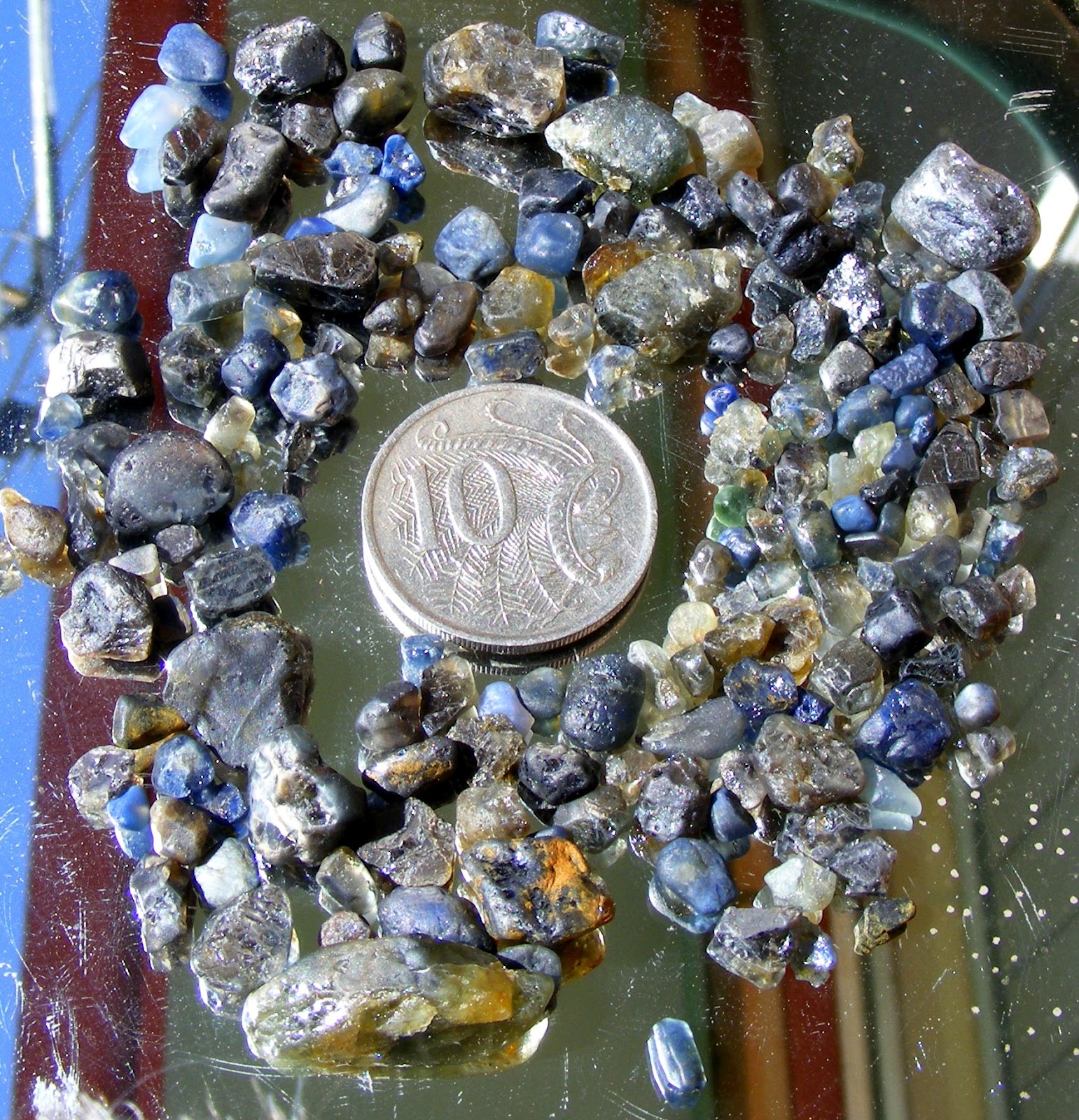
                                                  Corundum from Yarrow Creek
known as sapphire. To the miner, the term "corundum" means the nongem quality mineral.  It occurs in barrel shaped hexagonal crystals, pieces of crystals and rounded fragments. These may be up to 4 cm across. If broken, the mineral usually displays flat, very lustrous parting surfaces. Colour zoning both along and across the crystal is common.  

Zircon is plentiful, being usually a reddish brown colour. It can, however, be pale pink or colourless. The stones may show some crystal faces but are more often rounded.  

                                                     Zircon from Pretty Valley

Zircon is a highly lustrous mineral with a high refractivity which sets it apart from other minerals in the wash. Zircons have been found up to 3 cm across. 

Pyrope garnet is characteristically deep red in colour and usually dull in lustre (unlike zircon). Garnets frequently have rough, irregular surfaces, again unlike zircons which often display flat cleavage surfaces.

                                              Pyrope garnet from Yarrow Creek

Topaz is found as colourless to pale blue pebbles, sometimes 2 or 3 cm in diameter. Highly reflective cleavage surfaces are commonly seen, which distinguishes topaz from quartz but not necessarily colourless zircon. Topaz pieces tend to be larger than the other gemstones.

 
       Topaz Scrubby Gully Torrington

Enstatite and hypersthene are somewhat softer minerals than the others. They are occasionally found as brownish green to emerald green fragments which are quite unlike others in the wash.


                                          Enstatite and Hypersthene Yarrow Creek

Tourmaline is occasionally seen as black or brownish crystal fragments which have a characteristically rounded triangular cross section. The sides are often deeply striated.


Tourmaline and sapphire Pretty Valley

Cassiterite is exceptionally dense and has a distinctly metallic lustre. It is usually reddish brown to black and highly lustrous. 

Equipment Needed for Sapphire Fossicking.


Because water is nearly always available, gem fossicking around Glen Innes is comparatively simple. The basic equipment you need is a pair of sieves (coarse and fine), a shovel (the longer the handle the better), a plastic bottle with lid for your finds and a pair of tweezers for picking them out of the concentrate. 

For working hard ground like that at Wellingrove Reserve, a pick and crowbar are very useful. They are also invaluable in moving rocks in stream beds. A long handled shovel can help you get gravel out from under boulders, from pot holes and from cracks in the bedrock. A one metre steel probe is very useful for locating holes under sand or gravel while a jam tin and perhaps a piece of steel wire are excellent for scraping wash out from between boulders where gems have a tendency to get caught. Many people find a yabby pump valuable for extracting wash from cracks and other hard-to-get-at places underwater. 

Song Studies. Bible studies based on hymns and songs

Shoalhaven District Geology.

John G. Paix  ©

Glen Innes Business Enterprise Centre

June 1991


Wednesday, 6 May 2015

GEM DEPOSITS ALONG THE SARA RIVER, NEW ENGLAND NSW AUSTRALIA

GEM DEPOSITS ALONG THE SARA RIVER 
NEW ENGLAND NSW AUSTRALIA
This area is one of the most interesting gem producing regions in New South Wales. It’s also one of the most frustrating because of the difficulty in gaining access to the river and its tributaries. The map is extracted from the Records of the Geological Survey of NSW 14(1), which contains a valuable article titled “Sapphires in the New England District, New South Wales”. If you would like to download a copy, try Trove or locate DIGS.
Backwater-Kookabookra area, 40km south-east of Glen Innes
A further complication is that the river is sometimes called the Mitchell River; adding to the confusion is the fact that the nearby Mann River also has the Mitchell River as an alternative name!
There is plenty of information in issues of “Gold, Gem and Treasure” magazine, the Australian Lapidary Forum (ALF) website (here) and on DIGS (if you can locate it). 

Practically every tributary of the Sara (Mitchell) river is worth fossicking. Unfortunately, they are nearly all either on private land, in a National Park or simply nowhere near a road or track. If you wish to get onto private land areas, you are going to have to approach landowners for permission. Many of them will have already had enough of trespassers, shooters, people who dig holes and don’t backfill them, fire lighters and fence cutters, so be prepared for an earful.

It isn’t at all obvious from the map, but the river rises on the upper left of the map (west of Bullwarra), passes under the Backwater road (signposted as the Mitchell River) and flows south of Mt Mitchell via the Horse Shoe Bend to Kookabookra and beyond. The creek south of it is coloured green to indicate that it carries sapphire. The fact is, so do most of the streams and gullies on the map.

As a guide for readers, I’ll say something about the three areas I have actually been to. Firstly, upstream of the Backwater road bridge. We checked this out once for a possible Minerama trip but rejected it because of our poor finds that day. This was on Bullwarra property. The area was mined for gems, probably in the 1970’s, and all I found was a few bits of sapphire on the track (evidently spilled with gravel on the way to the treatment plant) and a nugget of cassiterite (tinstone) two or three centimetres across, which I saw lying on the ground. We were unaware of the fact that Cockatoo Creek was also gem bearing, otherwise we would have checked it out too.The presence of gold and cassiterite (tin) in the wash is normal for the area. Whether any mining was ever carried on in this creek I cannot say.

The Horse Shoe Bend section of the river is accessible by 4WD vehicles along the Horse Shoe Bend fire trail, which is reached by following McGarry’s Lane and Aqua Park Road eastwards off the Backwater road, a little south of the Yarrow Creek bridge. The descent is quite spectacular, with Crown Mountain (granite outcrops) straight ahead at the beginning of the trail. From the fossicking point of view, the problem is that most of the area is now in the Warra National Park. See this article from National Parks and Wildlife (here). Although much is said about the flora, fauna, history etc nothing is said about the reason many people would want to go there – fossicking. I have been there only once and found gold and small gemstones in the river easily enough. Another DIGS document (Reference number R00046781) makes for interesting reading at this stage. It’s a summary of the prospecting done in the area by Mr W Madgwick of Glen Innes in 1974. There is private property all around and trespassers are certainly not welcome.
Sara River at Kookabookra. Photo by Wwoofa, ALF
Most of the information available concerns the third area, at Kookabookra. This is well known as a fossicking area which produces quartz crystals, black tourmaline (schorl), gold, cassiterite (tin), topaz, sapphire and zircon. Fortunately for our generation, the early miners were only after gold and tin and discarded the rest. The actual area is well described in the blogs I listed near the beginning of this blog. This land is, I believe, a crown land lease held by the adjacent landowner who has given permission for fossickers to work there. Please respect this permission and do not trespass elsewhere, camp, light fires or leave rubbish behind. There is a further accessible area at the Sara River bridge a kilometre or so downstream, on the Ward’s Mistake road. This branches off the Pinkett road on the right a short distance back towards Glen Innes.
The Mitchell River Dredge from the Pinkett history book
This stretch of the river was extensively dredged, especially in the depression years. Sue’s grandfather worked as a woodcutter for the Mt Mitchell  (Mitchell River) dredge and her mother began her schooling at the nearby Kookabookra school. If you can find a copy, the little book “Pinkett, Mogg’s Swamp, Kookabookra Past and Present” (1988) makes good reading. 

Tuesday, 24 February 2015

SAPPHIRE DEPOSITS NEAR EBOR, NSW AUSTRALIA

SAPPHIRE DEPOSITS NEAR EBOR, NSW AUSTRALIA

Ebor is a small settlement on the eastern side of the New England Tableland. Its best known attractions are the Ebor Falls, where the river drops over a series of basalt flows, Cathedral Rocks National Park, Point Lookout (one of the most expansive views in Australia) and the Dutton Trout Hatchery, which you pass on the way to Point Lookout. Round Mountain is not only the highest point in New England, but you would have to travel several thousand kilometres northwards to find higher ground (Mt Bartle Frere, south of Cairns in north Queensland, in fact).

The sapphire deposits are located in places not far from the basalt margin (especially the outlying basalt on Round Mountain) and I would not be surprised if more remain to be discovered. The map adjoining is taken from “Records of the Geological Survey of NSW, 14 part 1” (1971). This includes an important article on Sapphires in the New England District. Ebor is on the extreme right of the included map. The DIGS reference is R00050764. The creeks highlighted in green are those known at the time to be gem bearing.

Apart from this map (which led me to check out the place) there are few other sources of information. There are several in the Dorrigo/Coffs Harbour Metallogenic Data notes and one in particular I found when searching DIGS – “V. Evans' Snowy Creek Sapphire Prospecting parish Rigney county Clarke, Ebor area” (DIGS reference R00039966).

Now, before you go rushing off in the hope of finding your fortune, take note of the fact that the areas mentioned are now in the Cathedral Rocks National Park where fossicking is not allowed. A reference about the park ( here) indicates the park boundaries and also that the remains of the sapphire prospecting are regarded as historic relics.
My own visits to the area included (a) Biscuit Creek at the top right of the map above (zero finds) (b) Native Dog Creek (black sand, probably ilmenite) (c) Boundary Creek, also top right of map
(black sand) and (d) Snowy Creek (the area highlighted in green on the map) (abundant black spinel).
This is a summary of the five areas indicated as gem bearing in the Metallogenic Mine Data (full title Metallogenic Study and Mineral Deposit Data Sheets Dorrigo - Coffs Harbour 1:250 000 Metallogenic Map (SH/5610, SH/5611) (explanatory notes)) The DIGS reference is R00037128.
Snowy Creek: described as a placer deposit carrying sapphire and topaz. “There is evidence of small-scale mining and fossicking activity along Snowy Creek upstream from its crossing by the Ebor-Guyra road. Position approximate. Not visited in the field."
Snowy Creek West: described as a sapphire alluvial placer.
Biscuit Creek: described as a placer deposit carrying sapphire and cassiterite, worked by dredging and/or sluicing.
Yooroonah (presumably near or in the Oaky River, south of the National Park): sapphire placer deposit worked by dredging and/or sluicing.
Oaky River, locality Yooroonah: sapphire and cassiterite placer worked by dredging and/or sluicing and by shallow pits.
This information is derived from the various reports concerning V Evans’ prospecting areas.
During 1978/79 attempts were made to have portion of Snowy Creek set apart as a fossicking area. Presumably this was in or near the land being prospected by Mr Evans. The land was subsequently incorporated in Cathedral Rocks National Park. Mr Evans prospected on both Biscuit Creek and Snowy Creek but no payable ground appears to have been located. The proposed fossicking area would have been on Snowy Creek.
The location of the various areas mentioned may be found on the map below, extracted from the Dorrigo/Coffs Harbour metallogenic map. It may take a little searching, but they are there!
418 – Biscuit Creek, 419 – Snowy Creek West, 422 - Snowy Creek, 667 and 669 – Oaky River/Yooroonah.


Saturday, 20 December 2014

SAPPHIRE DEPOSITS NEAR THE GWYDIR HIGHWAY EAST OF GLEN INNES

SAPPHIRE DEPOSITS NEAR THE GWYDIR HIGHWAY EAST OF GLEN INNES

Dirty Creek is in the centre of the map (from DIGS R00050764)
When I first moved to Glen Innes in 1988 I had with me a copy of the Records of the Geological Survey of NSW 14(1), which contains a valuable article titled “Sapphires in the New England District, New South Wales”. If you would like to download a copy, the DIGS reference is R00050764. The map at the end of the document is a useful tool for locating interesting fossicking spots. I need to point out, however, that, apart from Yarrow Creek, some of our best sites (eg Pretty Valley, Rainy Swamp, Back Creek and Frenchies Swamp Creek) are not indicated as sapphire bearing at all. The map in Mineral Industry 18 Gemstones 2nd Edition (1980) DIGS reference R00050830, is based on the earlier one.
Dirty Creek 1652 Tarcoodie 1704 (from metallogenic map)

One place seemed to be remote from all the others and that is Dirty Creek, near the Glen Elgin road turnoff from the Gwydir Highway about 30km east of Glen Innes. See the map extracts for guidance, also Google Earth. I now know that there are gemstones to be found in many creeks in the Glen Elgin area but it isn’t an area I’ve looked at very closely. Dirty Creek is crossed by the Glen Elgin road immediately after the turnoff from the highway. After a few hundred metres, the creek joins the Rocky River almost at the highway bridge. The Rocky River is known as the Timbarra River further downstream.

Please note that anything I say about access may no longer be true. Under no circumstances should you enter private land without permission.
Stock reserve gate
There is some kind of stock reserve covering the lower parts of Dirty Creek. About 300 or so metres before the Glen Elgin turnoff there is a gate opening into the reserve on the northern side of the highway. The creek runs through swampy and sandy country and you wouldn’t expect to find much in it. All I ever turned up were a few very waterworn sapphire and zircon fragments as well as black spinel and tourmaline. These were more abundant downstream where there are granite outcrops. Upstream you come to the boundary fence. Note that the area shown on the Grafton-Maclean metallogenic map as being the site of mining activity is a km or so upstream. Dirty Creek is shown as deposit number 1652
I haven’t examined Dirty Creek between the Glen Elgin bridge and the junction with Rocky River, but there are many granite outcrops in this stretch so there could be some gemstone concentrations waiting there for those who don’t mind getting wet.
Rocky River reserve entrance
Immediately after the highway bridge there is a track on the northern side entering what appears to be another reserve, through which the river flows. A lot of fossicking has been done here because there is usually a good flow of water and there is a lot of gravel in the river and its banks. I’ve only washed a casual sieve or two, but they always contained some gem material. It’s my guess that this has come down Dirty Creek and into the Rocky as I could find nothing upstream of the Rocky River bridge, though the usual problems of swampy ground and access to the river make this statement difficult to confirm.

The third gem bearing spot in the area is Tarcoodie, which I have not been able to locate, though the mine data information suggests that quite a bit work was done on the deposit. It is shown as deposit number 1704 and ought to be on the southern side of the road in the vicinity of the prison farm (afforestation camp). Stay out of that area!

Extracts from Grafton-Maclean Metallogenic Data

GR1652 (YJ0011) G Dirty Creek OCC sapphire modern placer (fluvial)
NAME(S): Dirty Creek Recorder(s): K. Ringwood, 24/11/1995
LOCATION Map sheets: SH/56-6, 9338-IV-S Coordinates (MGAz56): 404206mE, 6721488mN Locality: 29 km ENE of Glen Innes
Location method: 25K topo map Co: Clive Ph: Lewis Por: 42, 43, 45
MINING HISTORY Workings: dredging or sluicing Extent (m): d: l: 2000 w:
Prods and period:
Exploration:
HOST ROCK(S): clastic sediment, alluvium, Quaternary
DEPOSIT CHARACTER Ore minerals: (sapphire) Alteration:
Gangue: Production: Resources:
Ore genesis: modern placer (fluvial) Relation to host: stratiform Orientation:
REMARKS:
REFERENCES: MacNevin (1972), MacNevin & Holmes (1980)
GR1704 (YJ0010) G Tarcoodie deposit OCC sapphire modern placer (fluvial)
NAME(S): Tarcoodie deposit Recorder(s): H F Henley, 7/2/1992 & 24/11/1995
LOCATION Map sheets: SH/56-6, 9338-IV-S Coordinates (MGAz56): 409405mE, 6720368mN Locality: 36 km E of Glen Innes
Location method: 25K topo map Co: Clive Ph: Mount Mitchell Por: 21, 22; PMA
MINING HISTORY Workings: dredging or sluicing Extent (m): d: l: w:
Prods and period: Gem Exploration (July 1971 - March 1972)
Exploration: G and J Gems P/L (1988-present)
HOST ROCK(S): felsic intrusive, granite, Quaternary sediments, alluvial plain, Quaternary
DEPOSIT CHARACTER Ore minerals: (sapphire) Alteration:
Gangue: Production: Resources:
Ore genesis: modern placer (fluvial) Relation to host: stratiform Orientation:
REMARKS: substantial conventional production plant type