THE INVERELL METALLOGENIC MAP AND
MINE DATA SHEETS
Before reading this blog, it would be best to read the similar blog about the Grafton-Maclean map. This may be found here. The relevant reference number for the map and mine data sheets in DIGS is R00056102.
The Inverell package may be found by opening DIGS. The reference number is R00050906 (which includes the map). The reference number for the map alone is R00027907.
The Inverell map seems to be a poorer copy than the
Grafton-Maclean one, making an enlargement harder to read.
You will soon appreciate what a large number of
mineral deposits there are in the area, including at The Gulf (north west of
Emmaville), Tingha and the Copeton diamond fields.
Here is an extract from the map.
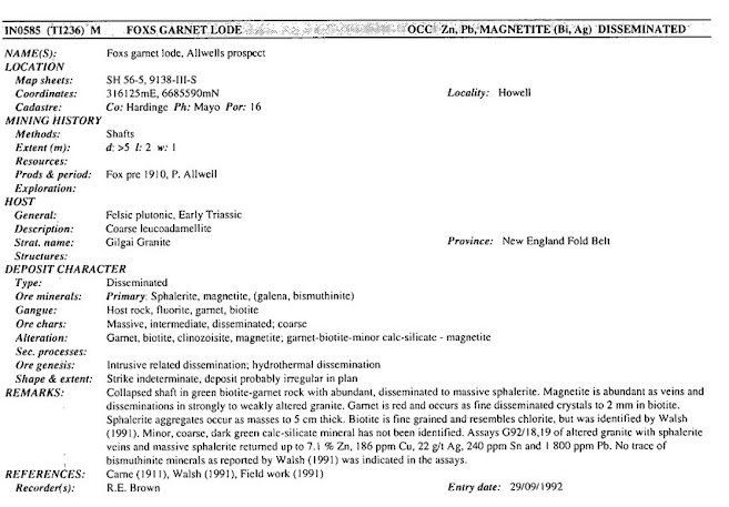
To illustrate the information to be found in the Mine Data Sheets, I’ve
chosen the deposit number 585. The location is south of Inverell, east of Copeton
Dam. Fortunately for us, the data sheets are in a
single volume, not dismembered like the Grafton sheets are. Upon opening the
data sheets you will find quite a lot of valuable information on the geology of
the region and the nature and formation of the many mineral deposits.
The data sheets commence on page 104. Deposit 585
will be found on page 377. Here is the information.
This is a typical set of information, in this case
for Fox’s Garnet Lode. I must admit I can’t locate it on the map – it’s quite a
congested area – but the information is all there for you to use. Mindat (here)
provides additional information when the deposit name is put in the search box.
Here is what I discovered.
By following the map Mindat provides (and choosing
the satellite image) you will discover that the Lode is just north of the Howell
Road, which leads to the old town site of Howell and the Conrad group of mines.
https://johnsbluemountainsblog.blogspot.com/2013/12/links-to-all-blog-entries-and-relevant.html All Blue Mountains blogs and videos
All New England and other Geology blogs and videos
Limestone Caves of NSW
Song Studies. Bible studies based on hymns and songs
Shoalhaven District Geology.


Hi, I was eondering if you have any information or knowledge about the Coronation/Commonwealth tin mine?
ReplyDeleteI have found that this site is very informative, interesting and very well written. keep up the nice high quality writing Glow Worm Tunnel 4wd
ReplyDelete